Hiking Mount Choungui
Last update: 06/23/2026
Our blog continues to grow thanks to you, our readers. This post may contain affiliate links, which means we can earn a small commission if you make a purchase through them, at no extra cost to you. This helps us to continue to bring you more and support our work!
After living on the island of Mayotte for almost four years, I recently realized it was time to tell you about this place—an island set in a lagoon that still holds a special place in my heart. For geography lovers, and for anyone who has not read my first article, here are what I consider the must-sees on a trip to the island of Mayotte. In this article, I am taking you to the famous Mount Choungui.

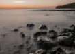
This French island in the Indian Ocean lies in the Mozambique Channel, between Africa and Madagascar. It is mainly made up of two islands: Grande-Terre and Petite-Terre. Scattered around them are several volcanic islets and white-sand beaches lined with coconut palms.


- Safari tour of Mayotte Island : take in the island's distinctive, unforgettable charm.
- Manta ray and dolphin safari : enjoy a unique experience swimming alongside these magnificent creatures in the lagoon!
- Whale watching : in season, take the opportunity to see these marine giants in their natural habitat.
- Introduction to scuba diving : a must-do activity, especially for beginners, and well worth trying!
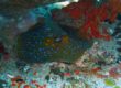
- Lagoon snorkelling : discover one of the most beautiful lagoons we have ever had the pleasure of exploring!
Discover more exciting activities in Mayotte and book ahead.
The island of Mayotte
For many people, myself included, this French territory is best known for scuba diving—its seabed, corals, and beautiful reefs—as well as its wildlife and plant life, including nesting sea turtles, baobabs, ylang-ylang plantations, and lemurs known locally as makis. Hikers will also find a handful of trails, best tackled during the dry season, as they can become extremely slippery when it rains. One of the island’s most beautiful hikes is the climb up Mount Choungui (Mlima Choungui in Shimaore).
Geologically speaking, Mount Choungui is a phonolitic extrusion—my geologist side coming out here—formed by volcanic material that is more recent than the rest of the island and created this distinctive landform.

Seasoned mountaineers can relax: this is a long way from the high peaks or major treks of Réunion Island. Mount Choungui is the island’s second-highest mountain, after Mount Bénara, and rises to 594 m.


How to Get to Mount Choungui
To get there, take the road south toward the village of Chirongui. As you leave the village of Tsimkoura, take the secondary road toward Kani-Kély, then continue toward the village of Choungui. The trailhead is about 500 m before you reach the village. Look for a water tank beside the road and a few picnic tables.
For those who like to plan ahead, here is the route on Google Maps. Mayotte is a small island, so do not worry—you are unlikely to get lost!
The Hike Up Mount Choungui
The hike begins on a generally well-maintained trail that runs through shady undergrowth beside banana plantations and other crops. The path is very easy as far as the left-hand junction, marked by a sign, where the real climb begins. I recommend avoiding the rainy season, however, as the trail becomes far too slippery. Beyond the undergrowth, the slope gradually steepens—and that is where the scrambling starts. You continue through shaded woodland full of roots, trees, and rocks, with slippery footing throughout. The middle section is tough, and you will often need to use your hands and grab whatever you can—roots, trunks, and more—to pull yourself upward.


I was not exaggerating when I said some sections were really tricky!
The final part of the climb is easier as the path winds out of the forest, and the first views are already impressive. Once you reach the top, a short trail leads to a beautiful 360° panorama over the entire southern part of Mayotte. From the summit, you can take in the island’s beauty: the coral reef, the lagoon, the mangroves, villages tucked into the bays, and lovely beaches. A distinctively shaped rock adds an extra touch to the setting.
A Few Tips
- Carry plenty of water in your backpack, as there is nowhere to refill and the climb is strenuous. The sun at the top makes it even tougher, so sunscreen is essential!
- At the time, it was possible to camp overnight at the summit and watch the sunrise the next morning. I did not get the chance to try it, but a warm fleece, a headlamp, and a sleeping bag would seem essential,
- Hiking shoes are a must (I have a friend who wanted to attempt it in flip-flops…),
- Allow 2 to 2.5 hours for the climb, a good break at the summit, and the descent.

Key Things to Know About the Mount Choungui Hike
- You do not need to be an experienced hiker to reach the top,
- Some sections of the trail are extremely steep,
- The summit offers sweeping views over the lagoon and surrounding villages,
- The descent is more dangerous than the climb,
- Allow 25 minutes to 1 hour for the climb, depending on your fitness level,
- I would not recommend this hike with a baby or young children.
There you have it—I hope you enjoyed this short hike up Mount Choungui. You should also know that, given the opportunity, you can take an ultralight flight over the island. The pilot will often fly around Mount Choungui, giving you an even higher vantage point and a wonderful view. The Mount Choungui hike is clearly one of the things to do in Mayotte. And if you enjoy hiking, why not also explore Lake Dziani (the subject of a future article coming soon)?
Afterward, unwind on one of the beautiful beaches in the south of the island, with Mount Choungui in view. It is quite a sight, is it not?

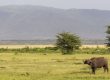
For anyone who enjoys Mayotte’s African atmosphere, I also recommend taking a safari in Lake Manyara National Park in Tanzania, a beautiful park I had the chance to explore a few years ago.
Enjoy the hike!

Written by Sylvain PONS
From 2011 to 2015, Mélanie and I lived for four years on the island of Mayotte. This allowed us to appreciate the island's beauty, its culture, and its endearing population. It was undoubtedly one of our best life experiences!
Despite our care, a mistake may have slipped into this article. If you find any, please don't hesitate to let us know so we can correct it as soon as possible and keep our information up-to-date!