The Dempster Highway: A Journey to the End of the World!
Last update: 06/18/2026
Our blog continues to grow thanks to you, our readers. This post may contain affiliate links, which means we can earn a small commission if you make a purchase through them, at no extra cost to you. This helps us to continue to bring you more and support our work!
Unless you have a particular interest in remote corners of the world that few people ever visit, chances are you’ve never heard of the Dempster Highway. I like to think I have a fairly solid knowledge of geography (I’m also a trained geographer, which helps!), yet I had never heard of it before we began planning a trip to the far reaches of Canada’s Yukon. This was our third trip to Canada, after a month on the island of Newfoundland and a quick visit to Banff and Jasper.
Then came the classic question: “But where is the Yukon?” Many people also asked us, “Why the Yukon?” My first instinct is to answer, “Because hardly anyone goes there.” I’m joking, of course, but there is some truth to it. It may sound a little paradoxical for someone who runs a travel blog, but I feel less and less drawn to the world’s most touristy destinations. I have very little desire to visit the heavily developed, tourist-packed places that dominate Instagram. Everyone seems to be heading to Bali, the Maldives, Iceland, Lapland—you name it—and I’m hardly interested anymore. To each their own, and I respect everyone’s choices, but personally, I want and need to discover places that feel far removed from everything—places where hundreds of people are not passing through every day just to take the same photo.
After doing some research—and knowing that our options from Guadeloupe were fairly limited—Mélanie and I decided to discover the Yukon Territory, a Canadian territory in the northwest of the country, bordering Alaska. Alaska had always appealed to me, which explains why we ultimately spent half of the trip there. But it was the Yukon that truly captivated me, especially the experience of the Dempster Highway, a roughly 733 km gravel road that runs from near Dawson City to Inuvik and, after another 138 km, to Tuktoyaktuk, the final community accessible by road, on the edge of the Arctic Ocean.
To me, this is the very definition of adventure and exactly what I crave most: exploring an isolated region with hardly anyone around, vast open spaces as far as the eye can see, and almost no tourists… At this point in my life, that is my idea of happiness—and certainly of a vacation. Through this article and these photos, I’m going to tell you about the experience and try to make you want to go there one day, though putting it into words won’t be easy! In fact, an adventure like this is almost impossible to capture in words…
Preparation
I’m not going to cover our entire trip here, as I’ll be writing a separate article about what to do in the Yukon and the must-see places we visited. In brief, we picked up our motorhome in Whitehorse and the first leg took us from Whitehorse to Dawson City, about 550 km to the northwest, along a generally good, paved road with few difficulties, apart from some roadwork and wildfires that were being brought under control in the area.
We arrived late in the afternoon and used our time in Dawson City to refuel the RV. We had already stocked up on groceries in Whitehorse, which I recommend—at Walmart, for example—as prices are lower and the selection is much better. We stopped at the visitor information center to gather details about the route, the conditions, the duration, what to do and see, the particular features of the area, etc. We also drove toward the airport, just in case. We borrowed bear spray ($20 deposit, refunded afterward) and then went to bed. We set off in the early afternoon, heading for the start of the Dempster Highway, about 40 km east of Dawson (where we arrived).


From the Start of the Dempster Highway to Tombstone Park (70 km)
A beautiful wooden bridge over the river marks the start of the famous Dempster Highway. After a meal and a souvenir photo, we set off. After a brief stretch of pavement beyond the bridge, we were finally plunged into the reality of what would await us for the next week (return trip): a dusty road in varying condition, which I’ll describe in more detail later. Admittedly, my perspective is slightly biased as I write this, since we had already completed the round trip on the Dempster Highway, but the 70 km stretch to Tombstone Park was relatively straightforward. The road was in relatively good condition when we drove through, and we drove along at 70 km/h without any problems. All around us? Nothing but pine forests, what I believe were birch trees, and a few other deciduous species. After about half an hour, we could see the first hills of the park in the distance. The scenery was beautiful, and the surrounding mountains gave this otherwise fairly flat opening stretch a special charm.
I had done a little research before setting off, but beyond crossing this park and traveling between the Yukon and the Northwest Territories (two neighboring regions of Canada—I’ll say more about that later), the Dempster is, of course, fairly hilly overall. It is also worth noting that the road is generally wide and raised above the surrounding landscape, which is reassuring in a way. We enjoyed the area’s mountainous scenery and took a break outside Tombstone Park Campground, where you can camp for a few days and explore the surrounding trails. However, you should be aware that most of the hikes are quite long, even very long, including the famous Grizzly Lake Trail, which is usually completed over two or three days. On the advice of the Dawson City Tourist Office, we decided not to stop on the way out and to hike on the way back.
Shortly after leaving the park, we were lucky enough to come face to face with a brown grizzly (according to us and the documentation we were carrying) casually crossing the road in front of us. A brief but beautiful moment! There’s no denying how lucky you feel when you experience the magic of these moments, especially compared with seeing one in a zoo!


From Tombstone Park to Eagle Plains (300 km)
We continued along the road, with beautiful mountain views all around us! The road alternates between smooth sections (60–70 km/h) and rougher sections where it’s hard to go faster than 40–50 km/h, with some serious potholes and stretches of loose gravel that can be unsettling when the vehicle starts to slide. We spent our first night in a small spot on the side of the road. There was literally no one around. We had been driving for four hours since we left in the early afternoon. Arriving here, in the middle of nowhere, felt almost surreal. No matter where you looked, there was nothing but pine trees as far as the eye can see, mountains more or less eroded by time and the elements, and this gravel road that cuts through the middle of this wilderness. And somehow, it made us feel completely at home.
That was another advantage of traveling by motorhome, something we were experiencing for the first time on this trip: the ability to stop anywhere without overthinking it, especially in an area as uninhabited as this! We were slowly getting to grips with the motorhome we had rented, although we soon realized that water—specifically for showering and washing dishes—would be our main concern. In fact, the motorhome has a 160-liter tank and, let’s face it, there was no way for all five of us to shower every day and do the dishes every day on such a limited supply. So we adapted and went into water-conservation mode. We quickly began filling the four-liter containers we had bought at Walmart with water from the rivers we passed, using it to wash dishes and heating it with propane for showers. That solved the problem. But it’s true that I would have thought the self-sufficiency of a six-person motorhome would be much greater. Of course, if you have to cook and wash dishes three times a day, and if five people need to shower every day, it’s impossible… That would have meant paying for a campsite every night, adding at least of at least $30 for a single pitch and $40-$50 for a pitch with electricity/water, depending on the location. That would have felt like a waste, especially when you know how much it costs to rent a motorhome.


The next day, we set off again, still in the hills after Tombstone Park. The dramatic sky cast beautiful colors across the landscape, and driving this road remained a pleasure. A few scattered showers kept the dust to a minimum. That was especially welcome whenever we passed other vehicles, especially trucks. Mélanie had passed one the day before in the middle of the road at full speed and the driver showed little sign of slowing down. But apart from that, we didn’t have too many problems with trucks. Most truck drivers slowed down properly, and we usually pulled over a little farther.
One beautiful landscape followed another as we crossed terrain shaped by distinctive landforms, all bathed in beautiful light. As the road continued, the terrain gradually became less rugged. We stopped by the river to refill our water containers and let everyone stretch their legs. The riverbanks were beautiful and the children had a great time throwing pebbles into the river!
One final, long stretch of road climbed up to the plateau at the Ogilvie Ridge lookout. This is a wonderful viewpoint over the surrounding valley, with information panels explaining the fauna, flora, permafrost and geology of the area. It’s very interesting and we spent two hours there resting, preparing a good meal and taking some photos of the beautiful surroundings.


Eagle Plains
About 110 km farther on—roughly a 90-minute drive—we reached another sign of civilization, the Eagle Plains area. It was time for a well-deserved break. There isn’t much there, but you’ll find a hotel, a bar/restaurant and a gas station (important!). We warmed up with hot chocolate and a slice of homemade cake!
Crossing the Arctic Circle
We decided to keep going, even though it was getting late, just to celebrate crossing the Arctic Circle. The evening scenery in the soft light—it was around 8–9 p.m. as we drove—was superb: more gently rolling, less dramatic, but just as beautiful. We stopped at the Arctic Circle crossing sign. There was a lovely view of the surrounding landscape and, of course, we took a souvenir photo.
The information panels also gave us some useful context. We drove on for a while, even though it was getting late. The stretch to the Yukon/Northwest Territory border was perhaps the least interesting stretch so far, though we may simply have been getting tired.


Crossing from the Yukon into the Northwest Territories
After a long drive, we reached this famous border where we left the Yukon Territory, where we’d been since the beginning of our motorhome journey, and crossed the invisible line into the Northwest Territories. The crossing felt all the more dramatic because the weather was terrible. Rain, gale-force winds and fog so thick you couldn’t see 20 meters ahead. It was an almost apocalyptic crossing! When we went through again on the way back, the weather was much better and the views from the pass and across the surrounding landscape were beautiful. There are magnificent views over the surrounding plains and the light across the landscape was striking. One beautiful landscape followed another as we descended the pass towards the Northwest Territories. At times, we passed very close to the mountains that have been cut away to make room for the road. There are some significant changes in elevation, and in rainy weather like this you have to be very careful as the muddy track can be slippery in places.
We continued on the Dempster Highway into our second night, not far from Midway Lake, but it was still a very long day on the road.


The ferry at Fort McPherson (Peel River)
After a pleasantly cool night in a quiet roadside spot, we were on the road again early the next morning. We had to drive the final 30 kilometers to the first ferry across the Peel River. There was nothing particularly remarkable about the crossing itself, but the views along the river were pleasant. We waited for the ferry (CF Abraham Francis Ferry), which was on the other side when we arrived. Funnily enough, it’s actually essentially a cable ferry that crosses from one side of the river to the other. After a five-minute crossing, we were on the other side. A few kilometers after leaving the boat, we stopped at the village of Fort McPherson, which seemed lost in the middle of nowhere. We spent just over an hour there, despite the dry cold that chilled us to the bone. It’s worth noting that a gas station was open when we passed through, along with a supermarket, a church, and a children’s playground…
The Mackenzie River Delta Ferry
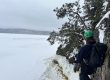
An hour’s drive from the first ferry brought us to the famous Mackenzie River. Its impressive cliffs can be seen in the distance along the banks of the river. I’m not quite sure why the name felt so familiar, but arriving there somehow felt like entering familiar territory. The river has an almost mythical quality. After doing a little research online (yes, we get internet with our local SIM card, which worked in some of the inhabited areas), we learned that the river rises from Great Slave Lake and flows into the Beaufort Sea, and therefore the Arctic Ocean. It is Canada’s longest river system, stretching more than 4,000 km from its most distant headwaters, is navigable for only part of the year (it is frozen the rest of the time), and forms the second-largest Arctic delta in the world after the Lena in Russia.
Arriving there felt far more impressive than I had expected. I went out to get some fresh air on the edge of the ferry, on that strip of land, which gave me the impression of being at the end of the world. It’s really cold, even though we were traveling during the warmer months, and I can’t imagine what life is like here in winter! On the other side of the river we could see the village of Tsiigehtchic, sitting quietly on the opposite bank. Life here must be unlike anything we know. The ferry makes a sort of triangle to pick up people from the village who want to cross the river at this point, and then crosses the Mackenzie River to get to the other side. This one is a “real boat”—in other words, it isn’t pulled by a cable, haha.


From Tsiigehtchic to Inuvik (127 km)
It was a solid two-hour drive from the ferry to the town of Inuvik, which also seems lost in the middle of nowhere, although Statistics Canada recorded a population of 3,137 in the 2021 census. In my opinion, the road leading there was less interesting. The terrain is even flatter, though there were still quite a few trees. We did it at night on the way back, at 11 pm, with a beautiful low sun, and that low light made the drive memorable.
Arriving in Inuvik
After a full day on the road, it was almost comforting to see a bit of ‘civilization’, even if the town itself was not especially picturesque. It was the first pavement we had seen since setting out, about 10 km from Inuvik, starting around the airport. The town reminded me of a former Soviet town (haha), with square buildings, very strange architecture and little obvious charm. In short, it did not immediately make us want to linger. We took a quick stroll along the main street of the town, which did not hold our attention for long, especially considering how cold it was. For context, the average annual temperature in the city is -9°C, so it is undeniably cold. To rest and recharge, we decided to spend the night at a campground in town (Happy Valley Campground—$35 per night) to have a proper shower, refill the RV’s water tank and empty the black- and gray-water tanks. We also took the opportunity to fill up with gas, which was painfully expensive here ($2.45 per liter), much more expensive than in Dawson, but we had no choice. It’s worth noting that there’s a large shopping center on the main street with everything you need, including a pharmacy and a Pizza Hut!
The shower felt wonderful, though we got dressed again very quickly!, and we ate that evening at the Mackenzie Hotel restaurant in town. The meal turned out to be very good.
From Inuvik to Tuktoyaktuk (138 km)
The next day, we left town for the last stretch of road before the Arctic Ocean. The change in scenery was striking, as there are hardly any trees along this stretch of road. By the way, a quick anecdote: the day before I spoke to some scientists who explained that they come to Inuvik every year to study the permafrost. Permafrost is ground that remains frozen for at least two consecutive years, and much of the town and surrounding region is built on it. In other words, the road runs across terrain underlain by frozen ground. Because of the climate and the ambient temperature, the ground is completely frozen at depth, and the buildings have to adapt to this, in particular by being built on stilts to reduce the risk of the buildings shifting or deforming. The scientists told me that north of the Arctic Circle, this type of ground is found almost everywhere in the region. They explained that you can roughly gauge local ground conditions by looking at the presence of trees. Larger trees generally suggest a deeper active layer above the permafrost.
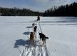
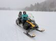
The rugged terrain had completely given way to flat land on this stretch of road and the landscapes are very different from everything we had seen since setting out. We were on the plain of the Mackenzie Delta and there’s very little vegetation, very few bushes, with little more than grass and lakes as far as the eye can see. It’s really beautiful and makes quite a change, even if it became a little monotonous after three hours on the road. Or perhaps the Arctic Ocean was simply calling us onward. The road is generally rougher than much of the Dempster, with lots of potholes and fewer changes in elevation. Extra care is needed on this stretch. On the way we passed a lot of people stopping to pick berries, which are everywhere at this time of year. I have to admit that we’re always a little wary of picking berries when we’re unsure (the film Into the Wild is always in the back of my mind)! We also saw quite a few snowmobiles parked along the road. I think they must be stored here during the summer, but these areas must be covered with snow during the winter and become travel routes during the winter.
Interestingly, this was where we saw the most wildlife since we started traveling. We spotted some birds, foxes, ptarmigans, squirrels, and what may have been marmots.


Discovering Tuktoyaktuk
After three hours on the road from Inuvik, we reached the end of the road, the community of Tuktoyaktuk, also known as ‘Tuk’. Our first impression was unsettling. In the distance we could see big buildings, old barrels, what looked like a sprawling dump on the side of the road as you arrive, and garbage scattered everywhere. It looks like an old industrial town, half abandoned. It did not appear that much effort had been made to make the town more attractive to the few tourists who had come to brave the Dempster and the elements to come here and touch the Arctic Ocean! Then again, I’m sure they have other things to worry about than meeting the expectations of a few geography enthusiasts like us!
Entering the center of town left us with mixed feelings. We saw a few people here and there, but it still felt a bit like a ghost town… We did get a few smiles from the local children though! We drove the last few kilometers to park in front of the famous Arctic Ocean sign. At last, there we were, after almost three days on the road, in front of the Arctic Ocean. The end of the road! We were still very proud to have managed to complete this legendary roughly 870 km route (one way). Although it wasn’t warm at all when we arrived (it was cloudy), we took a walk along the shore where we touched the water, of course. In the end, I only dipped my hand in, because I had clearly been fooling myself when I said I was going to swim in it! Especially since all of us were more or less sick with bad colds!


We decided to stop at the visitor information center at the entrance to the town, mainly to get Eilein’s phone number, a well-known local grandmother in the town who prepares local dishes for people passing through. We’d even chatted briefly on the Dempster Highway Facebook group. We went straight to her house and met this lady with her strong personality, openness, and honesty. I liked her immediately. We got to know each other and asked her what she could cook! She showed us around the kitchen. We went to get Pascale, who was staying in the motorhome, and started the meal with her, right there in her kitchen. It was a wonderful moment of connection and sharing with a local, the kind of experience I rarely come across and part of the reason why I travel. We had a wonderful hot vegetable and caribou soup, beluga, fried and dried fish—which was wonderful—and a spicy chili with caribou. Honestly, I loved it. The whole meal cost $50 per person for the whole meal, with homemade rolls and coffee/tea!
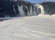
We spent the night in Tuk at the entrance to town, in the day-use area, a kind of rest area, perfect for us, overlooking a lake and a pingo, a landform characteristic of the region. A pingo is a mound with an ice core, partly covered by soil and vegetation (at least from a distance). From what I found, they occur mainly in the Arctic regions and the process is essentially due to the expansion of water when it freezes and to the cycles of freezing and thawing in these regions.
At sunset, I took some time to take some photos of the area, which looked beautiful in the soft evening light. The following morning, we spent some time walking around the town. The weather was fine and we made the most of the early-morning sunshine to explore the cemetery, the seafront and the local streets. After one last meal in this remote corner of the world, we made our way back.
I’m not going to tell you about our return journey as there is little to add. Throughout this story I’ve told you about it from time to time. There was nothing special about it, apart from the pride of having made the round trip without an accident, without any windshield chips, and without a single flat tire. Compared to what we’d heard, we felt we had come through remarkably well.


Hiking in Tombstone Park on the Way Back
I wanted to say a few words about Tombstone Park. It is only about an hour’s drive from the start of the Dempster and we decided not to stop there on the way out. On the way back, and on the advice of the Dawson City Tourist Office (go there before you leave), we decided to stop and hike the Goldenside Trail. According to the maps and the lady in the office, this is one of the few ‘fairly short’ hikes that you can easily do with children—ours were four and eight, for reference.
We started the walk in the late afternoon. We followed a beautiful trail through low bushes. There was no denying that it was cold, and an icy breeze froze our ears and noses! The trail is really nice, well laid out, winding its way up the mountainside. We met a few Quebec travelers dressed as if it was summer (haha!) but otherwise we had the trail almost entirely to ourselves. After an hour and a half of walking, we reached the summit. The children were in top form and even Téo, age four, walked the whole way without complaining. To be honest, I was quite surprised, as we don’t do much walking in Guadeloupe at the moment, and I would not have expected him to manage it so cheerfully…
Throughout the climb, the views of the valley leading into Tombstone Park are superb—even breathtaking when the weather isn’t perfect. At the top, the views of the surrounding area and other peaks and valleys are magnificent, and the scenery left all of us in awe. There we were, alone in the world, on top of a mountain, isolated in a remote region where obviously not many people pass through, and we could not have been happier. Despite everything, the cold soon brought us back to our senses and it took us an hour to get back down to the parking lot without any difficulty.
It’s a great hike if you want to enjoy the scenery and stretch your legs after all those hours on the road!


Is the Dempster Highway worth it?
In preparing for this trip on the Dempster Highway, I had imagined a few things and looked at a few pictures (but not too many). Even so, I found it a truly magical experience. It really is a legendary road trip—roughly 1,740 km round trip—which is pretty crazy when you think about it, isn’t it? What truly motivated me, though, to do it was the fact that it’s not very well known and relatively few people seem interested in it. And maybe that’s just as well, isn’t it? That it stays as it is and doesn’t become a tourist attraction that’s photographed for Instagram every 30 seconds. But that’s another discussion.
Anyway, to get back to the point, I would have thought the 870 km would be monotonous at times, but I was pleasantly surprised because the landscapes are quite varied. The first part whets your appetite, followed by the beautiful scenery of Tombstone Park, then the more subdued terrain, the crossing of two rivers, including the famous Mackenzie, the dramatic crossing of the border between the Yukon and the Northwest Territories, then the approach to Inuvik, and finally the flatter, less wooded part between Inuvik and Tuk!
It should also be said that three of us shared the driving, which made the journey much easier. Driving this route alone must be much harder, as you have to concentrate all the time to avoid potholes, rough patches, slowing down when a truck passes, being careful on descents and so on. As for the temperature, since I haven’t talked about it much, it was early August and the temperature never rose above 12°C, generally between 7 and 10°C, day and night. So be sure to bring suitable clothing!

As for the route itself, I think it was a very good idea to do it in a motorhome. However, we did see quite a few people in regular cars (so it is certainly possible) and, believe it or not, quite a few people on bikes, either alone or in pairs. I say “respect” because the route is exceptionally long. I say “wow” because the road is anything but flat, and it’s dusty and while there’s not much traffic, you end up swallowing dust every time you pass a car or truck. The physical and mental effort must be great, and the logistics must be demanding too. So, well done!
In terms of organization, the motorhome allowed us to stop wherever we wanted and be autonomous, which was ideal. Campsites are spaced fairly regularly along the route, so if you want the comfort of a shower, for example, you won’t be short of options. Otherwise, there are plenty of places to stop along the way.
Finally, the sensation of having completed this route is extraordinary. There’s a sense of immense freedom that I don’t think I’ve felt anywhere else since I started traveling. You’re literally in the middle of nowhere, almost always on your own, with little or no internet and none of the usual noise and distractions of everyday life. It really does cut you off from everything for days at a time, and in the end it’s a welcome retreat. The only disappointment, if there was one at all, was that we didn’t see too much wildlife. Given how much wilderness we crossed, we had expected to see more animals. Is this because of the many burnt areas we came across along the way? I don’t know, but it was upsetting to see, although we could see that nature reclaims the land very quickly!
Anyway, the Dempster is likely to stay with you if you like peace and quiet, emptiness, vastness as far as the eye can see, wilderness and the challenge of covering more than 1,800 km of gravel road round trip!
I’ll be back soon with another article on the Yukon. In the meantime, read Valérie’s article on what to see in Montreal.
See you soon,