Trou du Souffleur hike and Douaniers path
Last update: 04/23/2026
Our blog continues to grow thanks to you, our readers. This post may contain affiliate links, which means we can earn a small commission if you make a purchase through them, at no extra cost to you. This helps us to continue to bring you more and support our work!
We spent a long weekend exploring the north of Grande Terre, as we mentioned in our article on discovering Anse Castalia. Now that we’ve been living in Guadeloupe for 2 years, we’re really keen to cover as much of the island as possible on the blog. As we live at the other end of the island, and it has to be said that you can’t get to Anse Bertrand in a day, at least from where we live, we prefer to spend several days exploring certain parts of the island for the purposes of the blog.
Continuing our exploration of the north of Grande Terre in the backcountry, today we’ll tell you about our discovery and excursion of Trou du Souffleur for a hike on the Douaniers path along the customs trail along the north-east coast of Grande Terre, here in Guadeloupe.

To be honest, this is the second time we’ve attempted this hike. The first time was with Mélanie’s father. Last time we set off too late and, of course, turned back quickly because of the lack of shade. Today we’ve reached the end of the walk we wanted to do. I’ll tell you all about it in pictures.
Discovering the Trace des Falaises, Trou du Souffleur hike and Pointe du Souffleur
We decided not to make the same mistake as last time. We arrived at 9 am, but looking back, I think that’s a bit late if you want to avoid the heat. We have an excuse, we were a 30 minute drive away, but if you can, it’s better to start around 8am, or even earlier if you’re staying nearby. Anyway.
So we parked in the car park opposite the Porte d’Enfer, on the other side of the road. As it’s a weekday and quite early, there are only two cars there. But I imagine that at the height of the season or at weekends, the car park must be full. The kids and I got dressed and started walking around 9am. I hadn’t realized, nor had I checked the length of the hike (which I’m not used to, haha!) that it wasn’t that short!


The weather is fine, which promises a nice hiking trail along the cliffs with panoramic landscapes. I’ll explain in detail, but there are actually several routes to the Trou du Souffleur. However, it’s best to start from the Porte d’Enfer car park if you want to follow the whole of the Trace des Falaises, or at least the customs path we’ve indicated.
Cross the road, pass the small wooden hut and start the walking trail by taking the path on wooden planks that leads down to the beach. We were quite surprised, as this natural area is usually overgrown with sargassum. This was the case on my last visit and the smell was unbearable. I don’t really know why, but today the conditions are pretty good, even if the beach doesn’t seem very suitable for swimming, with the seaweed and murky water.

We straddle the small outflow to cross to the other side and walk along this arm of the sea that runs inland. It’s a truly magnificent and breathtaking place, the only place I know of in Guadeloupe where the sea is so deep. For those who know, it almost feels like you’re in a fjord, well, with a bit of imagination, because it’s already 35 degrees and we’re surrounded by tropical vegetation and wildflowers, haha.
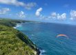
We start the walk along the seafront, which gives you a breathtaking overlooking of the impressive limestone cliffs ahead. In fact, depending on where you arrive, there is a very good viewpoint at the top of these cliffs that can be reached by car. I mention it here because it’s important. If you walk along this cove, you’ll also find some benches where you can just stop and picnic on your way back. It’s perfect for that!
The real trek runs along the limestone cliffs overlooking the sea. On your left are the Piton cliffs and Pointe du Piton, which are very photogenic. As you continue, the views of these cliffs and the sea front, battered by the swell from the east, are truly magnificent. You should be aware from the start that there is no beach along the entire route to stop and swim. You’ll be walking along the cliffs, which vary in height throughout the route. This is the main attraction.


The hiking trail along these cliffs is very pleasant indeed. Between you and me, the heat is oppressive even at 9am, so it’s good to have some sea air to cool us down. The hiking trail alternates between windswept cliffs and short stretches in the undergrowth where you can relax in the shade.
To be honest, the hike isn’t particularly difficult, and it’s a far cry from the steep hikes on the island of Basse-Terre. Everything is relatively flat here, but you have to be careful where you put your feet. Throughout the family walk, you will walk on the caye and along the cliffs. There are great views of several areas, including Trou Madame Coco, Pointe Percée, Accul à Desbonnes, Anse Belle Rose, Pointe à Desbonnes, Pointe à Tortues and Accul à Tortue.
Although it’s a beautiful walk along the sea, I have to say that it’s quite physically demanding. There’s very little shade and heatstroke is a real possibility! Louis made it without a problem, but Téo was tired after a kilometer and a half. Guess who had to carry him on his shoulders with my backpacking? In short, if I add my camera bag, which must weigh 7 or 8 kilos, I end up with 20 kilos on my back, and that’s no picnic, haha!


During the trek, we walked very slowly with the little ones and obviously took our time. After about 1:30 hour we reached the famous Trou du Souffleur, near Pointe à Tortue. It’s a huge hole in the limestone, a bit like the one at Marie-Galante, only smaller. We can’t see much because barriers have been erected to stop us getting too close. Fortunately, Mélanie is flying her drone, which gives me an excellent view of the surroundings. It’s pretty, but not exceptional, and the seafront itself is more interesting than this “simple hole”.

Continue along the path, still under the blazing sun, until you reach Pointe du Souffleur, about 2 hours walk from the start. Just before reaching the Pointe du Souffleur, we get a glimpse of the area. The famous natural arches are truly magnificent. I haven’t said much about them, but all the rocky points and little coves along the way are really superb, with beautiful turquoise water close to the cliffs. It’s a good idea to do it in good weather, as it’s much less interesting when it’s grey.
At Pointe du Souffleur we take a short break of about half an hour to enjoy the scenery and the waves crashing against the caye. Sometimes you can even feel that famous breath! Time flies. The children get tired quickly. So we decided to return at a faster pace. Louis followed without a care in the world, and to be honest, he did well. Téo was too tired to walk and I had to carry him on my shoulders all the way home. Suffice it to say, I was exhausted by the time we reached the finish. To give you an idea, it took us exactly one hour to get from the Pointe du Souffleur back to the car park without really stopping. That’s about 4 km.


All in all, it’s a nice walk of almost 8 km round trip. To be more specific, it is perfectly possible to continue from Pointe du Souffleur towards a place called La Mahaudière. A large part of the walk is along the cliffs and the final return is through the fields. I’m not really sure what the point of returning via this section is. You need to have parked a car here to be able to return to the Porte d’Enfer car park to collect your car. It is possible, but you need to plan ahead and have two cars.
To conclude this trek, what do we really think? It’s a change from the undergrowth and steep slopes of the island of Basse-Terre. But it’s good to have a change of scenery. It’s still a very pleasant walk, but it can get rather monotonous at times, so I don’t think there’s much point in continuing towards La Mahaudière. But why not! The next thing you need to be aware of is that there is almost no shade, so if you have children or a baby, you need to be very careful. It’s very hot. This can make the walk more difficult and this is not a short hike. We could have had a picnic at the benches along the inlet if we had planned a picnic for our return. I think this is the best thing to do if you’re planning this mountain hike to Trou du Souffleur.


Trou du Souffleur - Practical side
Here’s everything you need to know if you’re thinking of doing the Trace des Falaises via the Trou du Souffleur.
Where to start the hike?
As always, I invite you to read our detailed article on how to get to Guadeloupe, as this is obviously your starting point. Once you’re there, you’ll need to hire a car to be completely self-sufficient, which is the easiest way to visit Guadeloupe and the one we recommend most. Indeed, we increasingly recommend the website Discover cars, where you can compare prices from many car hire companies.
To get there, you’ll need to head to the north of the island of Grande-Terre, to the commune of Anse Bertrand. As mentioned above, you can go either way, starting from La Mahaudière or Porte d’Enfer, which we’ve found to be the most interesting. Here are the routes from Pointe-à-Pitre to Porte d’Enfer and to La Mahaudière.
It’s worth noting that from the road just before Porte d’Enfer towards the cliffs, there are a number of paths on the geoportail map. You’ll also find other people who have taken other, sometimes shorter paths to avoid going round the Pointe du Lagon, but which are really beautiful with a breathtaking panorama.
Where to stay nearby?
We chose to stay in the commune of Le Moule because it seemed more central. We stayed at the “Ti Cocoon”, which was good value for money. We’d recommend it if you’re looking for accommodation in the hikings area.
If you’re looking for accommodation closer to the hiking trail, here are some recommendations:
- Gîtes Les Bienheureux: a beautiful house with a warm welcome!
- Kaz à Klemence: We’ve heard good things about this accommodation, so go ahead and book it!
- Here’s another lovely house equipped to take advantage of the natural surroundings!
What to do in the area?
Here are some ideas for hikes and things to do in the natural area:
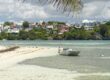
- Take advantage of the beautiful beaches on the west coast for a swim or a sunset: Plage de la Chapelle, Anse Laborde, Anse du Souffleur, etc.
- Explore Anse Castalia, to the northwest.
- Discover the slave marches at Petit Canal.
That’s all I have to say about the walk to Trou du Souffleur and the Trace des Falaises.
See you soon for another article. Don’t hesitate to visit our page with all the hikes in Guadeloupe that we’ve been able to do since we arrived here!

Written by Sylvain PONS
Since 2021, I've been living in the Guadeloupe archipelago with Mélanie and our two children. We are exploring these beautiful islands and discovering the treasures that we are happy to share with you!
Despite our care, a mistake may have slipped into this article. If you find any, please don't hesitate to let us know so we can correct it as soon as possible and keep our information up-to-date!