The best hikes in Lanzarote
Last update: 06/19/2026
Our blog continues to grow thanks to you, our readers. This post may contain affiliate links, which means we can earn a small commission if you make a purchase through them, at no extra cost to you. This helps us to continue to bring you more and support our work!
I’m continuing this series on Lanzarote with a guide to the best hikes on the island. With its volcanic terrain and desert-like scenery, Lanzarote offers plenty to explore on foot. Some travelers even cross parts of the island on multi-day treks, which must be an unforgettable experience. I joined a guided hike through the heart of Los Volcanes Natural Park and also completed several shorter walks, all of which I’ll cover below.
For me, hiking is one of the essential things to do in Lanzarote. I loved walking through lunar-looking landscapes filled with lava fields, volcanic cones, and even the vineyards of La Geria. One of the most striking things is how quickly the scenery changes once you start walking. Many trails have relatively modest elevation gain, but that does not always make them easy. Loose sand, uneven volcanic rock, and constant sun exposure can make even a short route tiring. Trees and shade are scarce, so it is important to set out properly equipped.
The aim of this guide is to introduce a range of hikes across Lanzarote. The island may not be large, but there is still a great deal to cover on foot.
The 10 best hikes in Lanzarote
1. Caldera Blanca in Los Volcanes Natural Park
This first route begins in Los Volcanes Natural Park, close to the boundary of Timanfaya National Park. It is important to distinguish between the two: independent hiking is not permitted inside Timanfaya’s protected core, where access is controlled. Caldera Blanca, however, lies in an area open to hikers, and even the drive to the trailhead takes you through extensive black lava fields.
The hike starts from a small unpaved parking area reached from Mancha Blanca. The route is generally easy to follow, although the ground is covered with loose volcanic stones and dark sand. The scenery soon makes the effort worthwhile as the trail climbs toward the rim of Caldera Blanca. The crater is roughly 1.2 kilometers across and rises a little over 400 meters above sea level. From the upper slopes, you can look toward the Fire Mountains of Timanfaya on one side and across lava fields stretching toward the Atlantic on the other.

Allow around two and a half hours for the complete round trip, with approximately 300 meters of elevation gain, depending on your pace and how long you stop along the way.
2. Volcán del Cuervo
After Caldera Blanca, Volcán del Cuervo is another route I would strongly recommend. It is one of Lanzarote’s most accessible craters and one of the few where the marked path allows visitors to walk inside. I visited it as part of a guided hike, although there is also a parking area nearby for independent access. Hearing that we were about to enter a volcanic crater immediately made the walk feel special; it was a first for me.


Inside the crater, the contrast is striking. Dark volcanic rock and ocher walls surround patches of vegetation that are noticeably denser than in the exposed landscape outside. The enclosed space feels surprisingly alive, and birds often nest in the sheltered rock. The volcano’s name is commonly associated with the crows seen in the area. Volcán del Cuervo is worth visiting both for the view from outside and for the experience of walking into the crater itself. From the nearby parking area, this is more of an easy walk than a demanding hike, although sturdy shoes are still useful. It can also work well for families with children who are comfortable on uneven ground.
3. Camino de los Gracioseros to Playa del Risco
I had planned to hike the Camino de los Gracioseros, but the weather did not cooperate. Strong wind and fog forced me to change my plans, which was disappointing because this trail looks remarkable. The route is steep in places and follows a dramatic path down from the area near Mirador del Río toward Playa del Risco.
Historically, this path was used by residents of La Graciosa, known as Gracioseros, who crossed by boat and climbed the cliffs to collect water and trade fish on Lanzarote. That is where the trail gets its name. Although the route is marked, the descent is covered with loose stones and requires care. Proper hiking shoes are much more suitable than sandals or lightweight sneakers. The views help make up for the rough ground, with turquoise water, ocher cliffs, and La Graciosa visible offshore. At the bottom, Playa del Risco feels remote and often nearly empty. Swimming is not recommended when the sea is rough, as currents can be strong.
Allow at least two hours for the round trip, plus any time spent on the beach. Avoid the trail in strong wind, fog, or wet conditions, as the exposed descent can become hazardous. Check the weather carefully before setting out.
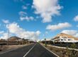
4. Montaña Roja (Playa Blanca)
Montaña Roja, whose name means “red mountain,” is the reddish volcanic cone that dominates the skyline around Playa Blanca. If you are staying in the resort, it is almost impossible to miss. This is one of the island’s shorter and more accessible hikes. Several informal access points lead up from the surrounding streets toward the crater rim. The path is sandy and can be slippery, but the climb itself is usually completed in around 30 to 45 minutes, depending on your starting point and pace.
From the top, the views extend across Playa Blanca and the surrounding coastline, with Fuerteventura often visible on clear days. I explored the lower slopes during a guided quad excursion in Lanzarote. We did not ride up the volcano itself, but the route passed close enough to appreciate its shape and colors.

5. Volcán de la Corona and Malpaís de la Corona
In northern Lanzarote, near Haría, Volcán de la Corona and the surrounding Malpaís de la Corona offer a quieter alternative to the island’s better-known hikes.
Volcán de la Corona formed thousands of years ago and produced the extensive lava field that reaches toward Cueva de los Verdes and Jameos del Agua. The route follows rough volcanic terrain toward the upper slopes of the cone. It becomes steeper near the top, but experienced walkers should find it manageable in suitable conditions. The reward is a broad view over northern Lanzarote and the coast.
Allow roughly three hours for the round trip, with around 300 meters of elevation gain. I would describe it as a moderate hike rather than an easy walk.
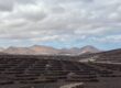
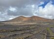
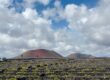
6. La Geria, Montaña Guardilama, and Tinasoria
La Geria is best known for its bodegas and wine tastings, but it is also an excellent area for walking. It formed the final section of my guided hike through Los Volcanes Natural Park. Here, the landscape changes from open lava fields to carefully arranged vineyard plots. Thousands of shallow hollows have been dug into the volcanic ash, each protected by a low stone wall and planted with a single vine. The result is one of Lanzarote’s most distinctive landscapes.
Possible starting points include La Asomada and Uga, with routes climbing toward Montaña Guardilama, one of the higher volcanic summits in this part of the island. The views stretch across La Geria and the surrounding volcanic terrain. Montaña Tinasoria, nearby, offers a slightly lower and often quieter alternative.

Allow around two to three hours, depending on the exact route and your pace, with approximately 300 meters of ascent. The trails are generally manageable but include loose and uneven sections.
7. Los Ajaches coastal route: Playa Quemada to Papagayo
Los Ajaches Natural Park is one of my favorite parts of Lanzarote. A long coastal hike begins near Playa Quemada and continues toward the Papagayo beaches. Reaching Playa de Papagayo on foot can take around three to three and a half hours one way, so this is a demanding outing unless transport is arranged for the return. The appeal lies in the wild coastal scenery, with cliffs, dry hills, and the Atlantic constantly in view.


The route is not technically difficult, but it includes narrow sections and frequent short climbs and descents. The main challenge is the heat and total lack of shade. Along the way, you can stop near coves such as Caleta del Congrio or Playa de la Arena, although swimming conditions should always be assessed carefully. I loved exploring Los Ajaches on foot between the coves and undeveloped hills. Playa de Papagayo is the busiest beach, while neighboring coves often feel much quieter. Playa Mujeres was the one I preferred for a longer stop.
For more ideas, see our guide to the best beaches in Lanzarote.
8. Femés to Playa Quemada (Ajaches, short version)
Because the full Los Ajaches route can be long, this option from Femés to Playa Quemada offers a shorter alternative. It stays mainly within the rugged hills of the park rather than continuing all the way to Papagayo. The hike starts in Femés, a village set high above the coast. Even before leaving the village, you get broad views over the surrounding ridges, lava fields, and Fuerteventura in the distance. The trail then descends through ocher-colored hills toward the sea.
One of the strengths of this route is how quickly the landscape changes from mountain terrain to the coast. The views remain open for much of the descent toward Playa Quemada, a small fishing village where fresh fish makes a fitting end to the walk. Allow around two to two and a half hours. The route involves a substantial descent, so remember that a return on foot would require climbing back up unless you arrange transportation.
9. Ermita de las Nieves and the Famara cliffs
This short route near Ermita de las Nieves offers one of the most impressive viewpoints on the island. The trail follows the high ground above Risco de Famara, the enormous cliff line overlooking the northwest coast.
The starting point is near the small chapel of Ermita de las Nieves, more than 600 meters above sea level. The panorama begins almost immediately, with Famara Beach below and La Graciosa in the distance. The path continues along exposed ground near the cliff edge, so it is not suitable for anyone uncomfortable with heights, strong wind, or poor visibility. On a clear day, you may also see Montaña Clara and Alegranza in the Chinijo Archipelago.
Allow around one and a half to two hours for the round trip. The route is relatively level, but the exposed terrain requires care.
10. Timanfaya: the Tremesana Route
The Tremesana Route is one of the few official walking routes inside Timanfaya National Park. It can only be completed as part of a guided park visit and must be booked in advance through the national parks reservation system. Group sizes are limited.
The route crosses terrain shaped by the major eruptions of the eighteenth century. Black lava, volcanic formations, and the gradual return of lichens and plants make the landscape especially interesting when explained by an official guide. As on my guided walk through Los Volcanes, the interpretation helps you understand how life slowly reestablishes itself on recent volcanic ground.


The current official English-language Tremesana visit is free, lasts approximately three hours including transportation, and covers around three kilometers. Groups are limited to eight participants, booking opens no more than one month in advance, and participants must be at least 16 years old. Closed athletic footwear is mandatory. The service is offered in the language selected when booking, so visitors must be able to understand that language.
Other hikes in Lanzarote
The ten routes above cover many of Lanzarote’s best-known hikes, but there are still several other worthwhile walks to consider.
Playa Blanca to Punta de Papagayo
I had originally planned to walk from Playa Blanca to Punta de Papagayo. After a busy morning, I chose to drive instead and explore the coves and low hills on foot. At the time, that was the better compromise for me. For hikers with enough time and energy, however, the coastal route is entirely possible. It follows dry terrain above the sea, with views of golden cliffs, turquoise water, and desert-like hills. Expect to stop often for photos.

Allow around three and a half to four and a half hours for the outward journey, depending on your starting point and stops. You may be able to arrange a 4×4 taxi for the return, but this should be organized in advance rather than assumed. Another option is to treat it as a full-day outing with picnic and swimming breaks in Los Ajaches Natural Park.
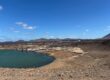
El Golfo, Playa del Paso, and Montaña Quemada
I stayed in El Golfo, the quiet village beside Charco Verde, Lanzarote’s famous green lagoon. The parking area near the viewpoint provides access to the beginning of this coastal walk. From there, the path heads across the dark shoreline toward Playa del Paso, a wild black-sand beach visible from parts of the Charco Verde viewpoint.

Beyond the beach, the route continues toward Montaña Quemada through old lava flows. Higher ground offers views back toward El Golfo, the cliffs, and the volcanic landscape of Timanfaya in the distance. Allow around two and a half hours for the round trip, depending on the exact route and conditions.
Haría to Mirador de la Montaña Ganada
This hike around Haría stands apart from many others because the surrounding valley is noticeably greener. The area is often called the “Valley of a Thousand Palms.” Starting in Haría, the route climbs toward Mirador de la Montaña Ganada. Most of the trail is straightforward, although the final section is steeper. As you gain height, the palm-filled valley opens below you, with views extending across northern Lanzarote and, in clear weather, toward La Graciosa.
Allow around two and a half hours for the round trip.
At Marina Lanzarote, the restaurants are more expensive and more modern, but you can still eat very well. The setting is more polished, with attractive harbor views. I would suggest going there for dinner and watching the sunset.
Finding somewhere to eat in Arrecife is generally easy. Unlike smaller villages such as Yaiza and Órzola, the capital offers a wide range of restaurants.
Volcán de la Montaña Colorada
Montaña Colorada is a good choice for anyone who wants an easy volcanic walk. It lies in Los Volcanes Natural Park near Volcán del Cuervo and Montaña Negra. I saw it during my guided hike, and the mix of red, ocher, brown, and black rock was especially striking. The colors shift subtly with the light, which explains the volcano’s name. The circular route is generally flat, clearly defined, and suitable for a relaxed outing.

As I walked nearby, I kept noticing slight changes in the colors and ended up taking far more photos than expected. Allow around one and a half to two hours, and wear sturdy shoes despite the modest difficulty.
That brings us to the end of this guide to the best hikes in Lanzarote. You can now choose the routes that appeal to you most and add them to your Lanzarote itinerary. Completing every hike would require a long stay, but there is no shortage of options for walkers.
Lanzarote is already an excellent hiking destination, but the hikes in Tenerife offer even more variety, with greater elevation gain and higher-altitude routes for different ability levels.
See you soon for more guides to the Canary Islands!

Written by Laura CALLES
Thanks to Mélanie and Sylvain, I had the chance to discover the Canary Islands, specifically Tenerife and Lanzarote, so that I could share these island paradises with you. Two real favorites of mine!
Despite our vigilance, an error may have crept into this article. If you spot one, please don't hesitate to let us know so that we can correct it immediately and keep our information up to date!