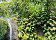
Galion Falls, a beautiful waterfall
Last update: 06/24/2026
Our blog continues to grow thanks to you, our readers. This post may contain affiliate links, which means we can earn a small commission if you make a purchase through them, at no extra cost to you. This helps us to continue to bring you more and support our work!
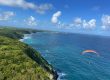
In this article, we’ll continue exploring the beautiful island of Guadeloupe, focusing this time on its inland landscapes and magnificent tropical forest. After taking you along the beautiful coastline of Basse-Terre on the “Sentier de la Grande Pointe” in Trois-Rivières, today, let’s discover Galion Falls, at the foot of the Soufrière volcano, in the Guadeloupe National Park.
We went there several times during the August COVID lockdown because we lived less than 5 km away, and honestly, the site is beautiful (especially during Covid times since there was almost no one there!). I imagine it must feel very different during Guadeloupe’s high tourist season, from December to April. You only have to look at the limited number of parking spaces near the Bains Jaunes to imagine how crowded the site can become! We’ve also written a short article for you to learn everything there is to know about the Yellow Baths.


Still, we took advantage of arriving in Guadeloupe in early August, when the crowds were smaller and most tourists had already left, to discover many of the classic places mentioned in travel guides. Among all the places to visit, Galion Falls is described as a must-see in many of these guides. At an impressive 40 meters high, the waterfall is still far less popular than the Carbet Falls and their three different hikes. I’ll tell you about those as soon as we’ve completed the first one.
As usual, I had to go back twice, both to gather enough information for this article and to take the photos I wanted. The first time, it was with Louis, my 5-and-a-half-year-old. For anyone wondering, as I’ll explain below, much of the hike is manageable with children and can even be done with a baby carrier. However, the final section involves slippery rocks and several fixed ropes, so you need to be cautious. Mélanie would probably say that taking a baby there is not especially safe, but that is exactly the kind of thing a mother would say… and, between you and me, she still hadn’t been there at the time! Let’s go for a walk!
Of course, and as usual, you’ll find everything you need to know about this hike at the end of the article! If you like hiking and if you plan on visiting a lot of different sites during your trip to Guadeloupe, it’s clearly worth buying a topographic IGN 1/25 000 map (see the map link below).
The Galion Falls hike (Chute du Galion)
As I said above, I hiked this beautiful waterfall twice. It must have rained the day before my first hike with Louis, because parts of the trail were quite slippery and muddy. When I returned alone the second time, the trail was much drier and therefore easier.
The hike starts at the same spot as many hikes in the Guadeloupe National Park, at the foot of the Soufrière volcano. You cannot drive any farther, so you have to park here, at an altitude of about 950 meters. From what I had heard, parking near the top can be difficult during the high tourist season unless you arrive early, which is something I recommend anyway. As on many tropical islands, clouds often begin to build around the middle of the day, and the risk of rain tends to increase as the day goes on. Anyway.
Once you have parked, head toward the sign showing all the hikes that begin here. You really are spoiled for choice. However, here, we will only talk about the Galion Falls hike. The sign at the start of the trail indicated 1 hour 15 minutes to the waterfall, while the current official estimate is about 2 hours 30 minutes for the round trip. On my own, I reached the foot of the waterfall in 45 minutes at a good pace. I would say that an average pace should get you there in about an hour. With young children, including my eldest when he was five, you should allow even more time.


The hike begins on the famous Pas du Roy, directly opposite the equally well-known Bains Jaunes pool. I’ll tell you about it at the end of the article, because I think it’s a must-see at the end of this hike (and of all the other ones, for that matter). It is a developed natural bathing area with lukewarm water, currently indicated at around 26°C, which can feel pleasant after a hike. But let’s get back to our story. The beginning of the hike is straightforward, following an almost entirely paved path beneath the shade of a lush forest. The atmosphere is really nice, very green so also very humid. When I returned the second time, I was alone on the first part of the trail and could hear birds and frogs all around me, which was lovely. Along this first 10-15 minutes section, you can see a few signposts introducing the area, the surrounding hot springs, the history of the area, etc. If you look carefully to your right, about 10 minutes into the hike, you may even see a fluorescent yellow hot spring flowing under your feet. You’ll also pass through several landscaped areas with steps, stairs, and other wooden railings. I imagine that everything is carefully maintained because it rains a lot in this area so everything can get damaged pretty quickly.
About 15 minutes after leaving the Bains Jaunes, you have to leave the famous Pas du Roy path, which climbs to the left, and follow the sign for Chute du Galion. From here, the path goes down on a gentle slope for about 1,5/2km. There is no major difficulty at this stage, but you will encounter plenty of roots and wet patches, weaving between pebbles, rocks, and wooden boards placed here and there to help keep your feet out of the mud. Let’s mention it straight away, if it rained the day before (as was the case when I went with Louis), you will end up with wet shoes anyway. There are simply too many passages that go through the mud…


The descent is really pleasant. You just observe the vegetation, ever so beautiful, but be careful where you put your feet while doing so. Several difficult sections have been improved with wooden walkways covered in metal mesh, similar to those we saw on hikes in New Zealand. They are very useful for preventing slips on the trickier sections. During this first section of the hike, do not hesitate to look around. There are a lot of epiphytic plants in the top of the trees, which need a support to grow. I also came across some flowers and wild orchids. Also note the presence of yellow mangroves with their characteristic roots. The trail is marked in yellow and was easy to follow during our visits, although signs and trail conditions can always change. In fact, considering the dense vegetation, cutting through the forest is unthinkable… At the beginning of the trail, in the early morning, temperatures feel really good, if a bit chilly in my opinion!
After about 30 minutes (depending on pace), we start the more technical and steeper downhill walk to the waterfall below. The trail changes from a southerly direction to heading east toward the waterfall. This part of the hike is a little more difficult than the previous one. There are plenty of roots and a few awkward passages, but nothing felt extreme during our visits. You will even cross a small gully (“Ravine Madame Toussaint”). Louis progresses more slowly here, but he still keeps on. On this route, and mostly before getting to the Galion River, at the bottom of the waterfall, there are superb trees with impressive roots and buttresses. If I am not mistaken, it is an Acomat Boucan, a classic tree of the region. It can measure more than 40m in height and is recognizable thanks to its gigantic external roots! By the way, I have not done it in French Polynesia, but I have promised myself to shoot a complete photographic report of Guadeloupe’s fauna and flora. It will always be interesting to show you all the richness of this beautiful island.


A final rope fixed to the rock helps us descend to the crossing of the Galion River. With a baby, you would have to be careful here. With Louis, who was six by then, everything went smoothly. The area is really beautiful and worth a stop to enjoy the atmosphere. You are reaching the end of the hike since there is only the final climb left, and it will not take more than 15 minutes to do. In any case, the downhill slope stops here as the trail climbs back up during the final section. We ford the river and head upstream to take some pictures. We can admire a beautiful waterfall a few meters high, flowing over the rock with an atmosphere that reminded me of the waterfall showers in Tahiti. We can also see another waterfall slightly further upstream.
We keep on hiking the end portion by taking the staircase which climbs on the opposite slope (roughly, just in front of where you arrived). More magnificent trees rise around us, impressive in both size and shape. After a few minutes, we can already spot the majestic Galion waterfall, at a distance and between the trees. On my first visit, I stopped here with Louis, as he was showing signs of tiredness and it was getting rather late. I didn’t want to take the risk of coming back at night since I didn’t know how much time I had left. The waterfall view is magnificent and Louis is amazed. He even helps me set up the tripod for a few long-exposure shots with my 70–180 mm telephoto lens, since I am too far away to use the wide-angle lens effectively.


We keep on walking on the end portion of the path. I reach a small pool at the foot of the slope, which I now have to climb using another rope fixed to the rock. The rope looks fairly recent, which is reassuring, so I continue with my tripod and camera over my shoulder. Depending on the weather, the rock can still be very slippery. Right now, the weather is fine yet not superb. I climb thanks to the first rope which brings me to a first flat spot from which we already have a sumptuous view over the waterfall. The sun is out, which is not ideal for the long exposures I want to take. I keep on climbing the rock thanks to a second rope which leads almost to the foot of the waterfall. A few more meters and I am standing at the foot of the waterfall, impressive at around 40 meters high.
I feel the weather is going to get better. I settle down quietly with my tripod for a session of long exposures, waiting for the sun to come out. The place is remarkably quiet, with no sound except the waterfall itself. The water falls at the foot of a wall where there is a small pool, not deep enough to bathe in but good enough to soak your feet. My first pictures are already quite good, but I’m still waiting for the sun.


And there it is! The weather improves, revealing blue sky as the sun lights both the cliff and the waterfall. It’s immediately much better for pictures! I admit I have time since Louis is back to school, so I settle down for a good half hour with my tripod trying to find original perspectives for my shots. I move from spot to spot at the foot of the waterfall which splashes me partly. Fortunately, I have a cloth to wipe the lens and filters. In short, here are some pictures that I am quite satisfied with. I’ll let you judge for yourself and tell me what you think in the comments!


I finally decide to pack up and go back quietly through the return path. On the way, I meet some people working on the trail (a company employed by the Guadeloupe National Park). They tell me they are there to repair, maintain and improve the difficult parts of the trail. That’s great. A nice discussion with one of them will allow me to learn more about the surroundings and life here.
The return is a little harder because almost the entire route is uphill. During my passage with Louis, I had to carry him a little to help him because he had enough. Coming back on my own, on the way back, I could feel the weather getting cloudy. Sure enough, I was caught in a shower near the end, fortunately once I had reached the Pas du Roy. For photographers, and everyone else, bringing a waterproof jacket or poncho is a very good idea, along with something to protect your backpack.
Finally, you may want to end the hike with a stop at the Bains Jaunes above the parking area. At the time we visited, there were not many people, but I suspect the site becomes crowded during normal periods outside the COVID lockdown, including with visitors who come only to bathe, as we have done ourselves. The pool is unsupervised, the water is not potable, and the health guidance displayed on site should be followed, including the recommendation not to immerse your head. In any case, spending fifteen minutes there to relax can feel very good after the hike. We practically had to drag Louis out of the pool because he was enjoying it so much! With the relatively cool air at this altitude, the water feels pleasantly warm.
I’m coming to the end of this walk. I hope you liked it, and that the story and pictures will make you want to go there! If you are looking for an easier hike, yet still nice, here is the Saut du Bras du Fort, in Goyave.
The hike in a nutshell
- Difficulty level: Moderate, with many roots and rocks, plus wet areas where your shoes may get soaked. The final climb is more technical and includes two fixed-rope sections.
- Duration: Around 2 hours 30 minutes to 3 hours, depending on your pace, trail conditions, and photo stops.
- Length: Approximately 5.5 km round trip.
- Type: Out-and-back hike.
- Ideal: The river crossing can be a pleasant place for a break or picnic when conditions are safe.
- Season: It depends. The waterfall carries more water during the rainy season, but the trail, river crossing, and rope sections also become more slippery and potentially hazardous.
- Remember: A waterproof jacket or poncho, proper hiking shoes, mosquito repellent, and waterproof protection for your backpack.
Below is an interactive map showing the Chute du Galion hiking area. You can use this map to check out all the hikes in the area, the ones we have already done and the ones we plan to do soon. We also wrote a page summarizing all the hikes in Guadeloupe.
You can also download the GPS track (.gpx) of the Chute du Galion hike, by clicking on the following link :
What to do nearby?
Of course and as you can imagine, I have not yet had the opportunity to do all the walks in the area. There really is a lot of choice for all levels, or almost. Starting from the Bains jaunes:
- The hike to the top of La Soufrière (the most famous)
- The hike to the top of l’Echelle (you can go there through the Galion waterfall trail via “la Citerne” or la Soufrière),
- The hike to the first Carbet Falls. It is longer and harder than by simply going through the second Carbet Falls (I’ll tell you more about it later),
- The tops of Carmichaël, Morne du Col and the Grande Découverte sector,
- Further north, explore the beautiful Moustique Canyon with its amazing water crossing!
- Why not consider canyoning in Guadeloupe?


Practical information for the Galion Falls hike
As usual, I will tell you everything you need to know about the practical aspects of the hike.
How to get to Galion Falls and find your way around
My usual quick recap. Of course, you will have to go to the island of Guadeloupe first. I’ve been using the Skyscanner flight comparator for more than 10 years now and it always allows me to find great prices.
Flight schedules, departure cities, airlines, and fares change regularly. If your dates are flexible, compare the available options through this flight search to see the current routes and prices to Pointe-à-Pitre.
Once there, you will have to rent a car to get around during your vacation.
As far as the site and the start of the hike are concerned, it all depends on where you come from. If you decide to stay a few days in the area, I suggest you find an accommodation on the heights of Saint-Claude. I’ll tell you more about it below.
From the city of Saint-Claude, it takes about 15 minutes to go up to the Parking des Bains Jaunes, where you will have to park. Here is the route.
A quick reminder. If you have a smartphone, you can:
- Install the Maps.me app to get offline maps during your entire stay. These are not hiking maps, but general maps. Note, however, that you will find a lot of trails on it and can still use it to find your way!
- Install the app “Rando Guadeloupe” (Android / Apple) which can help you find hikes on the island (even though I hope you will find the hikes thanks to our blog, lol). Internet connection required, except for maps downloaded offline beforehand.
Where to stay nearby
There really is something for everyone here. I don’t know them personally, but I got good feedback from:
- Les Cycas: a beautiful lodge in the middle of nature, in the Matouba district
- L’hôtel Saint-Georges: a rather good reputation for those who prefer hotels (on the heights of Saint-Claude),
- The guest house Habitation La Reine du Camp: a nice room in a house with a seaview, at the foot of the volcano
I’m coming to the end of this article about the Galion Falls hike. I hope I have succeeded in giving you the motivation to go and discover it! For those of you looking for a much easier and more accessible yet still nice walk in the area, I suggest you go for a family walk at the Bassin bleu. And if you like hidden gems, we also recommend this beautiful waterfall in the heart of the rainforest: the Saut d’eau du Matouba.
See you soon.

Written by Sylvain PONS
Since 2021, I've been living in the Guadeloupe archipelago with Mélanie and our two children. We are exploring these beautiful islands and discovering the treasures that we are happy to share with you!
Despite our care, a mistake may have slipped into this article. If you find any, please don't hesitate to let us know so we can correct it as soon as possible and keep our information up-to-date!