Soufrière Hike - Guadeloupe
Last update: 04/23/2026
Our blog continues to grow thanks to you, our readers. This post may contain affiliate links, which means we can earn a small commission if you make a purchase through them, at no extra cost to you. This helps us to continue to bring you more and support our work!
I’m back with another article about Guadeloupe. This one is a bit special because it’s a half-partnership. You might be wondering what this is all about? Today I’m going to tell you about the Soufrière hike, and more specifically about the Soufrière volcano. We’ve been living in this beautiful archipelago of Guadeloupe for a year and a half now, having left French Polynesia. Although we’ve explored the area and visited the neighboring islands (Desirade island, Marie-Galante and the Saintes archipelago, which includes Terre-de-Haut and Terre-de-Bas), we’ve only climbed the Soufrière volcano twice. I’ve deliberately provided links to the articles we’ve already written about these islands. Just click on the one you want to read.
Back to today’s topic: the Soufrière hike. As I said, we live here all year round. It’s different from being on holiday. But why did I tell you about a semi-partnership? A few months ago we climbed the volcano as a family during a day hiking trip. Since then we’ve wanted to try climbing with a guide. As you can see from all our articles on Polynesia, we’ve been in partnership with the Manawa website for many years now. This site specializes in outdoor activities in the heart of nature. We highly recommend this site if you want to book activities before you come to Guadeloupe. In partnership with them, we had the opportunity to try this hiking trail to La Soufrière with the local company “Vert Intense”. Located on the heights of Saint Claude, at the foot of La Soufrière, this company offers guided tours as well as canyoning trips, which we hope to try soon so that we can tell you all about them. Since this article was published, Valérie, a friend of ours, has been on a canyoning trip not far from here. She tells you all about it!
Actually, I’m talking about a partial partnership because we’ve already been to Soufrière on our own and this time we can compare our experience with that of a professional guide. I really didn’t want to separate these two experiences. They are similar in the sense that they are the same hike, but in the end they are very different. So, in this article, I’ve decided to give you our impressions of our ‘solo’ walk to La Soufrière, and then I’ll tell you about my recent experience of climbing with the Vert Intense guide. Finally, and most importantly for an article like this, at the end of the article I’ll give you everything you need to know about climbing La Soufrière. As usual, my practical side.
So, apologies in advance, this article may be a little long as I’ll be recounting both of our walking experiences. However, I’m sure you’ll enjoy our experience and be able to judge whether or not you need a guide on La Soufrière. But enough to talk, let’s get straight to the point.
Oh yes, I forgot, if you’re looking for a new experience, I invite you to explore the Parabole waterfall above the Bassin Bleu, a really beautiful spot!
Our solo experience on La Soufrière
We were lucky enough to make our first ascent of La Soufrière as a family, the four of us. I’ll talk about this in the practical section, but you should know that you can climb with a child or a baby. You have to take precautions, but it’s not too difficult if the conditions are good (which, I admit, is not always the case). Our first hiking trail to La Soufrière was in April 2022, almost a year ago at the time of writing. It’s a good thing I made notes of my impressions and conditions at the time, as it makes it much easier for me to tell you all about it.
If you don’t know, we live in the community of Vieux Fort. We’re about 20 minutes from the Bains Jaunes car park, the starting point for the Soufrière hike. It’s difficult, if not impossible, to predict the weather at La Soufrière. So we set aside one day at the weekend and that was it. Since 2004, the road to the Savane des Mulets has been closed after the earthquake in Les Saintes. As a result, we now start from the famous Bains Jaunes, at an altitude of 950 metres. It’s a popular spot for locals and, of course, tourists who come here for a dip before or after the walk to La Soufrière. The area is maintained and cleaned twice a week by staff from the Guadeloupe National Park. Here we go!
We managed to find a spot without too much difficulty and without being too far from the start of the walk. I’ll tell you more about it later. Mélanie decided to carry Téo on her back in a baby carrier with all the things she would need for the day (a bottle of water and a packed lunch). I’ll spare you the suspense, she changed her mind 10 minutes into the walk, haha. The walk starts just behind the yellow baths, on the famous cobbled path known as the Trace du Pas-du-Roy. This paved path was built at the same time as the Yellow Baths by the military in 1887.


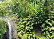
We set off quietly with the children. Everyone is motivated to finally climb La Soufrière. Starting from the Bains Jaunes car park, the walk is quite easy. We were immediately in the middle of a beautiful tropical forest, with lush vegetation that was a favorite with us. We enjoyed walking along the paved path, which was fairly easy to start with. Just after the yellow bath, don’t hesitate to look to your right, you will see an area where hot water is running and where a yellow deposit is clearly visible on the ground. On your right, along the path, you will see various information panels explaining the surrounding ecosystem, the flora and fauna, the volcano, etc. Approximately 300 metres from the start, you will come to a fork in the path. On the right is the famous Galion waterfall. It’s a beautiful waterfall, and if you have time on your trip, it’s well worth a visit. Don’t hesitate to read my article to whet your appetite. Let’s leave aside the hiking trail we’ve already done. Let’s start, if I may say so, the real climb. In fact, as soon as we reach this crossroads, things get serious.


From here, the slope becomes steeper and we follow a series of wooden steps through this beautiful tropical forest. According to my GPS, we’re at an altitude of almost 1000m. I have to admit that we’re starting to feel the early morning chill, as we’ve clearly been tropicalised by the years we’ve spent in the tropics. While Téo is being carried in my baby carrier, Louis enjoys the beautiful surroundings. As I said, we’re more or less changing at this point with Mélanie, who realises that it’s not going to be easy to carry Téo on her shoulders, who already weighs 12 kilos, and easily 5 to 7 kilos more if you count the water bottles and sandwiches… So we climbed this slightly more difficult part at the beginning of the trek, slowly, at the pace of the children (and of Mélanie, haha). At a normal pace, I’d say it takes about 30 minutes from the yellow baths to the famous Savane des Mulets.
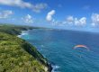
We were delighted to see the Soufrière volcano right in front of us when we finally reached the end of the forest. The weather wasn’t disastrous, but it was overcast. The summit had its head in the clouds. Nevertheless, the view is really beautiful. When the weather is good, as it was the second time I went with a guide, you can see the whole of the Saintes archipelago right in front of you, and even Dominica in the background if the weather is really good. Téo wants to stretch his legs. Louis is having a good time. So we let them loose in the car park and they set off like mad to explore the area.


From the Savane des Mulets car park, there are two ways to get to the top of La Soufrière. You can simply decide to go to the left or to the right of La Soufrière to climb up to the last part of the summit. Generally, people go up one side and down the other. We decided to go to the right, towards the famous Col de l’Echelle. The children are still keen to walk, so we leave them to it. We continue on the tarmac road that actually leads to the Echelle crater, at an altitude of 1,397 metres. To our left we see a huge boulder on the side of the road. Although I suspect that this is a boulder thrown from the volcano during a previous eruption, I won’t be able to be sure until the guide confirms it later. In this boulder, at the back, we can see a virgin resting against the wall on our way back.


A five to ten minute walk along the tarmac road will take you to the crossroads, where a sign will tell you that the Col de l’Echelle is about twenty minutes away on foot. The sign also states that the summit is an hour and 20 minutes walk away. Suffice it to say, with the kids wanting to walk and us taking photos on our own, we’re not quite there yet. Haha. At this point, we were treated to a few nice spells of sunshine, which gave us some very nice panoramic overlookings of the sea. Judge for yourself.


The sunny spells were relatively short. When we looked towards the summit, a huge pile of fog was waiting for us. Strangely, the children were still in good spirits, although the path up to the Col de l’Échelle wasn’t so easy. We did a series of sections with wooden steps and more technical sections. Nothing too crazy, but it’s definitely not a rolling path. Téo manages it like a champ and categorically refuses to be helped. But the steps are high for him. We were patient, we had the whole day ahead of us. As we climbed towards the Col de l’échelle, the weather became more and more threatening. The fog began to settle in. But the atmosphere is just as beautiful. It’s just different from when the sky was blue. But I really like the atmosphere. The vegetation around us is as crazy as ever, mainly low shrubs and ferns, mosses and lichens, all since we arrived in the Savane des Mulets. It’s true that the change in vegetation is really quite striking. Before the savannah, you’re in a tropical forest. Once you’ve crossed it, you’re on a wind-blown meadow, where the trees don’t seem to have had the motivation to grow very high.


The walk was advertised as taking 20 minutes. I think it took us an hour to climb to the Col de l’échelle with the children. The last few metres before the pass were so impressive because of the fog. We couldn’t see for 50 metres and the landscape in front of us was almost apocalyptic. Although I would have preferred a view of the sea, it was a unique experience. I might as well tell you that on the Col de l’Echelle, at 1264m, it’s freezing in the fog! I’ll tell you more about this in the practical section below, but it’s clear that you have to go to La Soufrière with a fleece and a K-Way. It’s practically essential.


There was no time to dawdle in the bitter cold and poor visibility, so we took the path that branches off easily to the west. The fog is still very thick. Visibility is very limited. We met up with other travellers and hikers who seemed to be catching up with us, especially if they weren’t carrying small children. On this occasion, however, I took Téo down from the mountain pass in his baby carrier as he was beginning to get tired. This part of the hiking trail (about 1km) is generally pretty good with a medium gradient. The path actually circles La Soufrière and gives access to the famous final climb to the top of La Soufrière. The scenery along this stretch is as crazy as ever, a mixture of fog and extremely low clouds. Judge for yourself. It must be something else in good weather!


When we reach the junction for the last climb, we are at an altitude of 1,350 metres. We can see the famous “Grande Faille”, a huge hole in the side of the mountain that is sinking, at the foot of this climb! As we passed through, the weather was clearly not good and this last section was the most technical and difficult, especially with the baby carrier and the weight on my back. Several times you have to climb up steps and over rocks of different heights. It’s quite easy. But it all depends on your level of fitness. Little advice: take your time and climb this last section slowly.


We finally reached the summit. The weather didn’t seem too bad. According to the feedback we had, the weather can be pretty disastrous up there. Even if it’s windy today, haha. We all put on our jumpers and k-way to cover up as much as possible. Louis is so proud of himself and walks all the way up. Téo is happy too, but he’s just been carried up the last bit, lucky you! The sun is shining and we can see the crater area. It’s inaccessible and closed by prefectural order (well, without a guide). This is clearly the main advantage of climbing with a guide. I’ll tell you more about this later. In particular, there are a number of areas where there is smoke and the whitish area is visible. I don’t have any lessons to teach anyone, but please respect the instructions and don’t go behind the barrier. I’ve learnt from my two ascents that you can be fined at the top. Of course, I’m not sure that the gendarmes are there every day and every hour, haha. I’m going to take advantage of the few spells of sunshine to try and get a few pictures of the place. Here are a few for your viewing pleasure.


Once the photography session was over, we returned to the tranquility of the summit bunker. We took our lunch break inside, sheltered from the wind, which was really nice. We headed back down when we’d finished. As they say, the descent is even harder on the legs than the ascent. Especially the last part, which is very steep. We decided to go back down the western path that goes around La Soufrière hiking area, the famous “Chemin des Dames”. At the time of our visit, storm Fiona, which struck in September 2022, had not yet hit. Since then, improvements have been made to the path (observed on my second visit, my guided hike) to make it easier to access from this side. Several sections of the path had been destroyed in the storm. In late 2022, this side trail was closed for a few months.


The descent is long. But it is not particularly difficult. On the way back, we had a few sunny spells, which gave us a nice panoramic view of the town of Saint-Claude below. We also caught a glimpse of the Monts Caraïbes just behind us. On the way down, we passed the back of the famous volcanic bomb where the Virgin is located. A few minutes later, we were back at the Savane des Mulets car park, where Téo could take a leisurely stroll to the Yellow Pool. The trek was well worth it, even though the road was closed.


We finally made it back in the late afternoon. Of course, with children who walk very slowly and at their own pace, it took us a long time. But who cares, we’re in no hurry, right? Everyone was very happy when we arrived at the Bains Jaunes car park. Louis and Téo enjoyed the hot water! A real pleasure. That’s it, I’ve come to the end of my account of my solo experience on the summit of La Soufrière. It was clearly a very good experience, but as I’ll tell you later, it’s really worth having a guide to learn so much. If you go off on your own, you run the risk of missing some really interesting things.
Guided hike at La Soufrière
Let me tell you about the walk I was able to do with Vert Intense. It’s something I’ve wanted to do for a long time, since the end of last year. But we ran out of time, and the arrival of storm Fiona didn’t help. Since we entered Lent at the beginning of March, La Soufrière has been really clear and beautiful for almost 15 days in a row. So I decided to contact Vert Intense again to organise this famous walk to La Soufrière with one of their guides. So this is my second time. I’m not going to tell you about the whole trek again. Even though the outward journey is not at all the same as the one we did as a family. In fact, we’re taking a path that only guides can use. It’s brilliant!
So I have an appointment at 7.30am at Vert Intense. The shop is in the last house at the top of Saint Claude, at the foot of La Soufrière. To be honest, at 7am it’s almost freezing with the windows open. Walking up, I can see the top of La Soufrière, which is quite clear this morning, and the fumaroles coming out of the right side of the crater are still perfectly visible. On arrival I met Teddy, our guide, and the other participants. The welcome is really nice and Teddy seems to be laughing a lot, haha. A cup of coffee is offered on this beautiful morning, which is a real treat. Teddy explains how the day is going to work and hands out a small waterproof bag containing our mask for entering the crater area, which is closed to the public. For me, this is the main advantage of going with a guide, in addition to the explanations you get throughout the day, as I’ll explain later. We left Vert Intense in our cars at 8 o’clock in the morning, heading for the summit of La Soufrière.


Once everyone is ready, we start the walk trail. Teddy explains that the yellow baths are cleaned twice a week. If they weren’t, they would be the same color as the hot spring I told you about. It’s yellowish, just after you leave the yellow bath on the right. We all continue together on the path trail to the Galion Falls. Teddy gives us some great explanations of how the forest works, its different levels and how it feeds and grows. It’s really interesting and very entertaining the way he presents things. In particular, we learn a lot about what people think of as a creeper. In reality, a vine starts from the ground and grows upwards. What we see coming down from trees are just roots. We are given a long speech and explanations about the famous “bois bandé”, a tree with aphrodisiac virtues, but dangerous for real.


We continue on our way. We slowly climb to the car park of the Savane des Mulets. The view of the Soufrière volcano is majestic and completely clear as we emerge from the forest. I move to the side to take a few photos and change the lens to get a couple of close-ups of the fumaroles that emerge from the crater. It’s really quite magnificent. Turning towards the sea, something I hadn’t really seen on my first ascent, we got a breathtaking view of the Saintes archipelago in the distance.


Back at the car park, Teddy explains that after the earthquake that hit Les Saintes in 2004, there was a lot of damage to the famous road that we used to have access to. It is now closed. He also confirms that the large boulder in the car park is a volcanic bomb, estimated to weigh 21 tonnes (the one currently surrounded by concrete). Teddy knows the hiking area very well and reminds us of what happened during the last eruption of the Soufrière volcano in 1976. He explains the periods of doubt at the time, the decisions of the prefect, the evacuation of 76,000 people, all in a world where there were almost no telephones or radios! Of course, everyone feared the arrival of fiery clouds, known technically as pyroclastic flows. This is what completely destroyed the town of Saint-Pierre on the island of Martinique in May 1902, when Mount Pelée erupted. In the end, 30,000 people died in Martinique as a result of this terrible disaster. If you don’t know what pyroclastic flows are, they are characterized by a mixture of water vapor, volcanic gas and solid particles, all at very high temperatures and flowing at speeds of up to 200-500 km/h. These fiery clouds can travel an average of five to ten kilometres. In the largest eruptions, they can travel more than 20 kilometres.


It is also a reminder that in 1976 the hiking area was closed for eight months, just long enough for things to return to normal. Continuing towards the Col de l’échelle, we stop again in front of the large boulder on the left. This is where a statue of Notre-Dame de Guadeloupe was erected after the volcano woke up in 1956. The boulder is estimated to weigh 92 tonnes and is from the 1798 eruption (he will show us the area where the boulder was ripped off, on the other side of La Soufrière). He also tells us that during the 1976 eruption, the inhabitants of Les Saintes saw things flying over their islands, probably volcanic bombs. Is this a true story?
We continued on our way. We took the path that leads to the Col de l’échelle, the same one we took as a family. The big difference this time is that, after a quarter of an hour’s walk, we quickly leave the path and head west towards the volcano and its crater. At the top of the mountain you can see the former home of Haroun Tazieff, the famous volcanologist who came to study the Soufrière volcano in particular. His decisions during the 1976 eruption led to a major political crisis.


Finally, we set off on the famous hiking trail, which is closed to the public. It literally goes straight up to the summit. The slope is very steep and obviously this path is more complicated than if we’d continued on the classic path around La Soufrière via the Col de l’echelle. Still, it’s really nice to walk on a path that few people use. Teddy explains that this whole sector is monitored by inclinometers and other instruments. After a while we arrive at the Great Fault, created during the eruption of August 1976. It’s impressive in its size and Teddy explains a lot of interesting things, including how Soufrière’s activity is monitored, but also some interesting basics about the materials that make up the volcano, the color of the rock, the minerals it’s made of, how long it takes to cool down, etc.


We continue on our way towards a hole formed during the 1836 eruption. Along the way, Teddy passionately explains various aspects of the local flora, in particular the 270 species of ferns found on the Soufrière volcano. We learned some interesting things about mosses, lichens and what I thought were ferns: lycopods, a mutation of lichens in response to the lack of light. We made a quick stop at the 1836 hole, which is now almost completely covered. What’s really interesting is this: Standing about ten metres away from the group, I can feel heat coming out of the ground. Looking more closely at the ground, I noticed that one area was completely scorched. When I put my hand on the ground, the soil and the fumes are almost boiling. You can definitely feel that you’re in a volcanic zone. Teddy also tells us that a new species of lily has been found nearby, the mountain lily. The weather was beginning to cloud over at this point, but the views of the surrounding area were as beautiful as ever. At times we were treated to some very nice rays of sunshine.


We continue to climb up the same steep slope towards the fissure that was created by the eruption in 1976. We’ve been hearing a thud for a while now and it’s really quite impressive. The sound of water vapor intensified as we got close enough to see a gaping fissure covered in yellow sulfur deposits. It’s a really beautiful sight and we enjoy staying and watching for a while.


We continue a little further. We stop at the edge of a fissure created by the 1956 eruption. There are no sulfur deposits here, but a deafening noise emanates from the fissure.
We continue past this impressive hole for another five minutes. This is where we make our official stop. Teddy asks us to take the masks out of our backpacks and explains how to put them on. We really do have strange faces with these masks on. From this point on, masks are compulsory to enter the crater as the gasses released can be harmful to your health. With our masks on, we set off for a 20-minute walk inside the volcano’s crater.
I have to say that arriving at the crater is really impressive. The area is covered in a whitish color and there are huge fumaroles everywhere. Teddy takes the time to explain some interesting things about the area. You can really feel the heat coming out of the ground. Several times Teddy lets us try to put our hands on the vents of some of the fumaroles. Even 1 metre above the fumaroles you could literally burn yourself because the heat is so intense. We passed Napoleon Crater, Gouffre Tarissan and Dupuy Crater on our way around the area. The site is really impressive and it’s the first time I’ve seen such intense volcanic activity up close. Large deposits of sulfur can be seen in several places. The photos don’t do justice to the beauty of the place. It was very cloudy when we visited. But here are a few photos to give you an idea.


Teddy explains that he has to be the police almost every day because people don’t respect anything. They go behind the barrier from the top of the mountain when they’re not supposed to. I still remember when we went up with Mélanie because Louis kept having fits because he wanted to go into the crater area, which you can’t do unless you’re accompanied by an official guide. There’s no debate about it, it’s clearly written down. However, during our visit with Teddy, two groups showed no respect for anything. They left as if nothing had happened in this dangerous volcanic area. So once again, without wishing to preach, take a guide if you want to visit this breathtaking area.
We leave this very special trip area and return to the hiking path that leads to the summit. At last we can take off our masks, which feels really good. Strangely, Teddy doesn’t suggest we climb to the top. It doesn’t seem to bother him too much, as the main point of hiring a guide is to be able to cross the crater zone and learn about the area. When I asked Teddy about it, he told me that if anyone else wanted to do it, they could. We then quietly made our way back down the famous “Chemin des Dames”, the path we’d taken as a family around the westside of La Soufrière. I took the opportunity to descend into the great fissure, something I hadn’t seen on my first visit. This hole is really impressive.


It’s also worth mentioning that the Chemin des Dames has been considerably improved since the passage of storm Fiona. As I mentioned in my article, several sections were destroyed. Nevertheless, it’s interesting to note that there really are a lot of people going up and down. It’s clear that we’re still in the tourist season and that hiking La Soufrière is one of the must-do activities on a trip to Guadeloupe. I use the descent to quietly answer a few emails and save some time, haha! We come back down as planned via the Savane des Mulets and the path that quietly leads to the Yellow Baths.
To be honest, I found it a really great experience. I’m not really used to walking with a guide. But Teddy is perfect for the role. He’s really passionate about what he does. He knows his stuff, he’s funny, he’s entertaining and he takes lots of breaks for those who are having a bit of trouble. What’s more, we really learnt a lot, both about the flora and fauna and the geological and morphological aspects of La Soufrière. The historical aspect is also very well explained. In my opinion, it’s really worth going with him if you’re going to Guadeloupe and don’t necessarily have the opportunity to come back and climb La Soufrière on your own.
To go or not to La Soufrière with a guide?
I’m just giving my personal opinion here. Everyone has to see what they can do, as they say. My opinion is probably a little biased in the sense that I live here and have had the opportunity to climb La Soufrière myself. Of course, I’m sure I’ll climb it again and again in the future. However, if you’re a tourist on holiday in Guadeloupe and you’re unlikely to be back in the area any time soon, then in my opinion the best way to do the climb is to do it with a guide.
No, I’m not forcing you to do it, and the trail is clearly signposted so you won’t get lost. But that’s not really the point. As I said, I think the main, if not essential, advantage of going to La Soufrière with a guide is that it gives you access to the area of the famous crater that is closed to the general public. What’s more, you’ll be on paths that no one else does (except those who have no respect for anything, haha). Finally, the guides will be able to tell you a lot about the history, geology, local flora and fauna and many other interesting little details. Another important point for those who are wondering is that a tour with a guide won’t really break the bank either. The trip I took cost just €45, which is really affordable.
Of course, I’m not saying I’ll do it every morning, but I’ll have the opportunity to return several times. I’ve learnt a lot of things that I find really interesting and which, in my opinion, clearly justify the value of going up with a guide. If, like me, you’re convinced that this could be of real interest to you, I invite you to book the guided trek to La Soufrière on the website of Manawa, with whom I’ve formed this partnership. In case you’re wondering, of course you won’t pay anything more and I’ll get a small commission, which will allow me to continue writing articles of this kind.
Hiking at La Soufrière - Practical side
As usual, here’s everything you need to know about hiking at La Soufrière.
How to get to the Soufrière volcano?
Obviously I don’t have anything to tell you here, but first you have to get to Guadeloupe. I won’t go into the details of what I wrote in my article on the subject. I invite you to read it in full. Although airfares have risen recently, at the time of writing it’s still possible to find tickets for around €600 from Paris or Montreal.
To get to La Soufrière, you first have to go to the island of Basse-Terre. Funnily enough, as I chatted to some of the people in my group, I realized that some of them were from the commune of Saint-François, which is on the opposite side of the island. I don’t understand why people are so keen to stay in Sainte-Anne and Saint-François when the nature, vegetation and tranquility are so much better in the south of Basse-Terre. But these are personal choices. If you don’t want to complicate your life, I would advise you to stay somewhere in the south of Basse-Terre so that you are only a quarter of an hour from the starting point of the hike. If you have to drive 1? hours from Saint-François, all at 5am, I don’t think it’s worth it.
What is the best route to take for a hike in La Soufrière?
To get to La Soufrière, and in particular to the summit, there are basically two options:
- You can either go to the east of La Soufrière, via the Col de l’Echelle, to circumvent the crater and then make the final ascent.
- Or you can simply climb the Chemin des Dames to the west of the crater, and of course finish on the final ascent, which is the same as on the other side.
Everyone will have their own opinion. Personally, I find the scenery and environment much nicer on the Col de l’Echelle side. But maybe that’s a matter of taste. On the other hand, I think the Col de l’Echelle is a bit longer and perhaps a bit more difficult.
If you’d like to download the GPS track of the walk, HERE it is!
When is the best time for a hike to La Soufrière?
That’s really the main question you should be asking yourself. If you’re a tourist here for two or three weeks, you probably don’t have much choice. Fortunately, things work out for the best as most tourists come between January and March, which is generally the best and coolest season. It’s also the season with the least rainfall. When I spoke to Laurence from Vert Intense afterwards, she also told me that, contrary to popular belief, September is often the month when La Soufrière is clearest (the trade winds have stopped).
The rainy season begins in June or July and lasts until October. During this season, although it is possible to enjoy fine days, the summit of La Soufrière is often shrouded in cloud.
As for the time of day, most people go early in the morning and that’s definitely what I recommend.
Firstly, the clouds often lift after or as you leave, which is preferable. Secondly, and more importantly I think, if you want to park in the Soufrière car park, you’re going to be walking for a very long time, especially in high season, as the car park fills up quickly. Ideally, I’d say starting the walk at 7am is a good choice. You can also do a late afternoon climb to La Soufrière for the sunset, as many locals do. But that’s another story, as you’ll need a fleece for the cold and, above all, a headlamp for the descent at night. I wouldn’t recommend it if you’re not used to walking or if you have children.
If you’re on holiday and really want to climb La Soufrière, I’d advise you to check the weather forecast. I use the famous Winguruu website which gives a good overview. Just make sure that the “Cloud cover (%) high / mid / low” and “*Precip. (mm/1h)” lines are as low as possible, ideally at “0” or with dashes. This will guarantee you some visibility and little or no precipitation.
How difficult is La Soufrière hike?
To be honest, that’s a difficult question to answer. I’d say it depends largely on your physical condition, although all the guides classify it as ‘difficult’. If you’re used to walking and you’re in good shape, the Soufrière hike should be no problem for you in terms of reaching the summit. Admittedly, it’s quite long and some parts are steep (especially the last 20 minutes), but there are no really dangerous parts.
On the other hand, if you are not used to walking, it might seem quite difficult, especially in the steepest parts. In that case, I’d really advise you to take your time, stay well hydrated throughout the walk and take breaks.
Personally, I don’t find the walk any more complicated than that. The conditions are relatively easy to walk in and compared to other hikes I’ve done in the middle of the rainforest with roots, mud and rain, this one is much easier in my opinion.
For your information, La Soufrière hike is :
- About 7.5km round trip
- About 600m ascent
- Time: between 2 and 4 hours (more if you’re taking photos and with children, haha).
Is it possible to hike La Soufrière with children or a baby?
Again, there’s no simple answer. It depends on whether you’re a mum or a dad who might be reading this, haha. In all seriousness, you’ll often read on the left and on the right that hiking with children under the age of seven or eight is not recommended, which to be honest, Mélanie and I think is rather “harsh” advice.
We’ve climbed with our two children, aged two and seven, without any problems. We’ve also met parents who have climbed with babies without any problems.
I’m not saying you can’t do anything, but some sections are a bit steep and the rock is a bit technical, so you have to be really careful with your children. Above all, the weather has to be taken into account. Don’t forget to take a fleece and a K-Way for your children in case the weather gets bad or it starts to rain. I remember when we arrived at the summit with two little ones, and Téo, who was only two, was freezing. We put a coat and a hat on him to protect him from the wind.
So of course you have to be careful, especially with a baby, who can get cold very quickly with the wind at the top and the rain. It can get really cold. So in reality I wouldn’t recommend it with a child under 2, for example.
What equipment to take to hike at La Soufrière?
Here’s what I recommend you take with you on the Soufrière hike:
- A rucksack: this is an obvious one, but you’ll really need it to carry your things around during the day.
- A K-Way: I’m joking when I say this in my article, although I went without one for the second time. La Soufrière was completely clear, but I still managed to get a heavy shower on the way back. In my opinion, this is something to think about.
- A fleece: depending on the time of year, especially if it’s windy, it can get really cold in August.
- A snack: of course it depends on whether you decide to eat at the top or not. It all depends on your pace. If you set off early in the morning, around seven o’clock, you could be back before lunchtime.
- Water: It can get very hot at times, especially on the days when the sun is shining. Teddy, our guide for the day, told us that the day before the fire brigade had to intervene 16 times during the day because of dehydration.
- Something to protect you: a hat, a bob, a cap, whatever you like, but it’s important.
- Something to nibble on: it’s always a good idea to have something to nibble on in case you get hungry or have a hard time.
- A camera: this is the photographer talking, but I think it’s going to be nice for you to immortalize this moment. If you’re a photographer and have several lenses, I’d recommend a wide-angle lens for very wide shots of the landscape, but also a telephoto lens for details. Ideally, I’d also recommend using a polarizing filter to eliminate haze and reflections. A neutral density filter (GND) is very useful if you don’t want to burn out the sky, which would be completely white without it. Personally, I used the following equipment:
- Sony A7III
- Tamron 20mm f/2.8
- Tamron 70-180mm f/2.8
- Hoya Slim Polarisant filter
- Nisi V7 Filter Holder + CPL (tested on our blog, you can check it out)
- GND Soft Filter 0.9 Edge
- My Olympus TG6 which I always carry with me.
Where to stay in the Soufrière area?
Obviously, there’s a wide range of accommodation to choose from. I’ve chosen three that I think are worth mentioning, all located not far from where you start hiking:
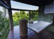
- Les Bananes vertes: This is a very well known gîte in the area and is highly appreciated for its facilities, cleanliness and comfort. The setting is beautiful and breathtaking, with a magnificent swimming pool and a wooden look. The hosts are very welcoming and will be happy to advise you on what to do in the area. The breakfasts are first class and the rum offered on arrival is much appreciated. We can’t recommend it highly enough for a wonderful immersion in nature!
- Les Pimentiers de Papaye: This is a charming property offering independent, quiet and comfortable accommodation. Breathtaking overlookings of the mountains and the sea. The hosts are always available and helpful, offering useful tips for hiking and exploring the area. The table d’hôte offers tasty pizzas and an excellent meal. Guests recommend this accommodation for its ideal location and the friendliness of the hosts.
- Les Cycas: very interesting accommodation, close to many walks. Set in beautiful grounds, the houses are very well equipped. The hosts are lovely and will give you a warm welcome. You’ll love the peace and quiet, the open spaces and the huge garden. The Soufrière area is ideal for walking. The owners are very helpful and make sure you have everything you need.
- La Vieille Sucrerie de Saint-Claude: La Vieille Sucrerie de Saint-Claude is a very nice gîte that will charm lovers of nature and tranquillity. The owners will give you a warm welcome and make sure your stay is comfortable and enjoyable. You’ll love the stunning sea views and the lush garden.
Alternatively, you can search for all accommodation in the town of Saint-Claude.
Book your accommodation near La Soufrière
Find your future accommodation using the interactive map below!
What other hikes are in the area?
I’ll end this article with a few ideas for walks with panoramic views in the area. There’s something for all tastes and abilities, and clearly we haven’t explored everything yet. If you don’t already know, we’ve written a whole page listing all the hikes we’ve done in Guadeloupe since we’ve been living here. It’s complete with GPS points so you can import the itinerary before you set off.
Among the classics and the most famous, I recommend
- Les chutes du Galion: a magnificent, easily accessible waterfall that I recommend 100%.
- The Nez Cassé hike: It starts a little lower down and climbs to a peak to the west of La Soufrière. We’ve been told it’s great, so we’ll give it a go.
- The Échelle hike: This is the summit you see to the east on the climb up the Col de l’Échelle, above Haroun Tazieff’s house.
- The Carbet Falls: I haven’t written an article about them yet, but it won’t be long. The first fall is the most impressive, but also the most difficult to reach.
- Grand Étang Hike: An easy walk in very humid surroundings in the heart of the rainforest, great fun for the whole family.
Of course, there are many others to discover.
This is the end of a very long article about hiking in La Soufrière. I hope you’ve enjoyed these pictures and that they’ve whetted your appetite to climb this volcano. I highly recommend you pick up a hiking guide if you’re staying in Guadeloupe! Don’t hesitate to come and dream (or not?) by reading about the hiking trail to the DC3 plane wreck behind La Soufrière!
See you soon for another adventure with panoramic views!

Written by Sylvain PONS
Since 2021, I've been living in the Guadeloupe archipelago with Mélanie and our two children. We are exploring these beautiful islands and discovering the treasures that we are happy to share with you!
Despite our care, a mistake may have slipped into this article. If you find any, please don't hesitate to let us know so we can correct it as soon as possible and keep our information up-to-date!