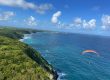
Hiking through Canyon de la Moustique
Last update: 06/24/2026
Our blog continues to grow thanks to you, our readers. This post may contain affiliate links, which means we can earn a small commission if you make a purchase through them, at no extra cost to you. This helps us to continue to bring you more and support our work!
Since arriving here in August 2021, we have really enjoyed hiking in Guadeloupe. The link below takes you to a page where we have gathered all our hiking experiences on this beautiful island. You will also find dedicated articles and a map showing the different hiking options across Guadeloupe and its islands. You can also download the GPS tracks for every hike we have completed. If you are looking for an enjoyable, moderately challenging hike during your trip to Guadeloupe, I recommend the Chute du Galion at the base of the Soufrière volcano. It is a lovely way to immerse yourself in the tropical forest.
Back to the subject of this article: our trip to the famous Canyon de la Moustique. I came across this place while looking for ideas for a weekend outing. The only catch was that it was not exactly a regular hike, but more of a water adventure. In other words, we had to swim! While my parents were visiting for two weeks, Mélanie and I set off on this hike with the group of friends we often spent weekends exploring the forest with.


The hike takes its name from the Moustique River, which rises in the heart of Guadeloupe National Park near Morne Moustique. The trail is in the commune of Petit-Bourg on Basse-Terre.
All right, let’s go! I will take you through this beautiful canyon, an experience quite different from our usual weekends in Guadeloupe. As usual, you will find all the practical details at the bottom of the page, including the duration, difficulty, and GPS track.
For another beautiful place to explore in Guadeloupe, take a look at the Bain des Amours.
Hiking through Canyon de la Moustique
I did plenty of research into the hike and how to reach the starting point, but the information I found online was outdated. I will explain in more detail below, but the traditional route from Duquerry was not accessible when we visited, so we started from the Boucle de Desbordes trail instead.
After looking into this alternative, we decided to make our way through the forest, as we could not find an established GPS track. The first section through the forest involves a steep, challenging descent. Fortunately, one of our friends met some hikers who knew a good alternative route to Canyon de la Moustique.
I turned on my GPS to record the route, which you can download at the end of the article. The track shows the exact route we followed at the time, but conditions can change quickly and should always be checked before setting out. We left the Boucle de Desbordes parking area, passed two houses farther up the road, and entered the forest. Within five minutes, we reached the Duquerry crossing, a small stream that we crossed without getting our feet wet. At the time, a sign marked with a red arrow showed the way, and the trail was easy to follow.


The path climbs to a plateau with open views of the surrounding countryside and grazing cattle. Luckily, the weather was pleasant. We followed a dirt track for about 10 to 15 minutes until we reached the point marked at 211 meters on the IGN map. This is where the difficult section begins. We turned right into the forest and began descending a very steep slope with a drop of about 50 meters. The first part was manageable, but the descent became progressively harder. It was not really a defined trail, but a long descent down an extremely steep hillside. Mud, roots, rocks, and trees made every step something to negotiate carefully. We moved slowly, doing our best not to slip or twist an ankle. I would not recommend this particular approach with children. We did meet families in the canyon, but they had taken a different route.


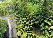
After about half an hour of descending, we finally caught sight of the Moustique River at the bottom of the slope. As so often along Guadeloupe’s rivers, the setting felt wonderfully secluded, surrounded by lush tropical vegetation. We had to cross the river here. During our visit, we managed to cross without getting our feet wet, although that hardly mattered with a 300-meter aquatic section still ahead of us. Once across, we followed the visible path along the right bank, on our left as we headed upstream. We followed the dry edge of the river until we reached the entrance to the canyon, and it was a beautiful sight.
A group of about ten people was on its way back when we arrived. I admit that I would have preferred to find the place empty, but it did not spoil the experience. The setting is remarkable. We stood looking at the entrance to the gorge, which seemed to appear out of nowhere. Water filled the narrow canyon ahead, while dense vegetation covered the surrounding walls. Huge butterfly-shaped leaves and white flower spikes clung to the canyon walls, forming a dense patchwork of green.


We all prepared to enter the canyon, as the water becomes deep very quickly and walking soon becomes impossible. I will cover this in more detail in the practical section, but a waterproof bag is essential for keeping your belongings dry. Hoping to keep my camera gear dry, I carefully packed my Sony A7III, lenses, and tripod in a waterproof bag. I did not want to miss the chance to take photos inside the canyon. The water felt surprisingly cool as we entered. After about twenty meters, we had to start swimming. Everyone managed their belongings as best they could. I pushed my backpack along the surface, with the waterproof bag packed inside it. The whole group entered the canyon as it curved to the right. Looking up from the middle of the canyon made us feel very small. Ahead of us, vegetation covered the steep walls. After a short bend and about five minutes of swimming, we could already see the far end of the canyon. The swimming section itself was fairly short, taking around five to ten minutes. Take your time and enjoy the surroundings. The current was gentle during our visit, although river conditions can change quickly. For part of the canyon, however, the water was too deep to touch the bottom. For us, the main obstacle to bringing children would have been the steep approach we used. Even so, this is an unsupervised river environment with deep water, so each family needs to assess the conditions and swimming ability very carefully.
At the far end of the canyon, we passed through a small waterfall between two massive rocks. The scenery was beautiful, and we took our time enjoying it. Most of the group continued slowly upstream. I used the opportunity to set up my tripod and take a series of long-exposure photographs. Thankfully, everything stayed dry. Writing this article made me realize that I should invest in a proper waterproof backpack, especially for my camera equipment. It would make photographing future water hikes in Guadeloupe much easier. For now, I use a reliable Ortlieb dry bag that I have owned for years, placed inside a 45-liter backpack from Decathlon. It is not an ideal setup, because the backpack itself is not waterproof and water collects at the bottom. I will share what I eventually bought.


I sometimes let the others go ahead so I could concentrate on taking photos. The vivid vegetation clinging to the rock walls was a pleasure to photograph. Beyond the canyon, the riverbed widened and became relatively easy to follow upstream. You can turn around here, but I thought it was worth continuing a little farther upstream. The rocks are slippery, so watch your footing. I was already thinking about buying new hiking boots with better grip.
I kept taking photos along the way, even though carrying a tripod with the camera attached was a little awkward. About ten minutes farther on, we found a photogenic spot where a fallen tree stretched across the entire river. We continued upstream for another ten minutes before stopping for a while. With such a large group, it was difficult to keep everyone motivated when none of us knew what lay ahead. Looking at the contour lines on the 1:25,000 IGN map, I was not convinced that continuing much farther up the Moustique River would be worthwhile. The riverbed remained much wider upstream, suggesting that we were unlikely to find another narrow canyon like the one we had just crossed.
In the end, we decided to have our picnic right there. The setting was lovely, and we were lucky enough to enjoy some sunshine. We were perfectly happy there. We then turned around and retraced our route through the canyon. We met more people on the way back than we had on the outward journey. Starting early in the morning is the best way to limit the crowds. Although this is not a conventional tourist trail, the site can still be busy.


The return journey, especially the climb back to the plateau, was hard on the legs, although it felt less awkward than the descent. Eventually, we made it back to the parking area. The walking distance is not especially long, but the very steep, informal descent makes this a demanding outing. The aquatic section requires confident swimming, suitable conditions, and properly waterproofed belongings.
I hope you enjoyed following the hike through the text and photos. If you have any questions or know of another route, feel free to let me know so I can add it to the map. If you want to relax on beautiful sandy beaches, I recommend crossing the Mamelles road and heading to the beaches near Deshaies.
Quick summary of the hike
- Difficulty: Medium to difficult due to the steep and challenging descent and crossing a gorge (it’s not your typical hike, you got it!).
- Duration: Approximately 3 hours round trip if you spend some time exploring upstream beyond the canyon.
- Distance: Around 4 km round trip
- Type: Aquatic hike
- Conditions: Go only in settled, dry weather and avoid the river after heavy rain
- Download the GPS track: Here it is!
The IGN map below shows the location. It comes from our general map of hikes in Guadeloupe, where you can also explore other routes in the area.
What to do nearby
Here are a few other places worth exploring nearby:
- Valombreuse Garden: It is a beautiful botanical garden and an easy place to explore with the family. It is slightly smaller than Deshaies Botanical Garden, but just as enjoyable in my opinion.
- Le Saut de la Lézarde: One of Guadeloupe’s best-known waterfalls. This is more of a short outing than a full hike.
- Le Saut du Bras du Fort: Another pleasant family walk, with the option of having a picnic by the river.
- Drive along the Route de la Traversée, which is nearby and especially pleasant in good weather. You can make a quick stop at Cascade aux Écrevisses. It is popular, but only a two-minute walk from the road. Alternatively, explore the riverside trails around Maison de la Forêt, which offer easy walks and a chance to discover the local wildlife. There are also several food stands nearby.
You can also consider a visit to Chutes Moreau.
Practical information for Canyon de la Moustique
Here are the main practical details to keep in mind.
How to reach Canyon de la Moustique
First, of course, you need to get to Guadeloupe. Flights from France are often easiest to find from Paris, so compare prices for your dates using a flight comparison tool. Depending on the season, direct flights may also be available from other French cities. Available airlines and routes vary by date, so check current schedules before booking.
Once there, a car is the most practical way to reach this trailhead and explore Guadeloupe. Bus services exist, but they are not suited to accessing this remote starting point.
Finding the trailhead is not especially straightforward. As mentioned earlier, the “classic” route described on another website was not accessible when we visited. The GPS track I uploaded, shown on the map above, records the route we followed. It should not be treated as a guarantee of current conditions or access. The other route via Duquerry, Gropiot, and Poirier, as marked on the IGN map, crossed private land and the gate was closed when we visited. Do not enter private property without permission.
For the route we took, head to Petit-Bourg on the east coast of Basse-Terre, then follow the road toward Duquerry. We parked near the starting point of the Boucle de Desbordes hike. Here is the exact route from Petit-Bourg. From the parking area, we walked back along the road for about 100 meters and turned right just before the large white house with the red roof. Access conditions and informal markings may change, so verify the route locally and do not rely on the GPX track alone.
What to bring for this hike
This section deserves a little more detail than usual because this is an aquatic hike involving deep water and swimming. A waterproof dry bag, or better still a waterproof backpack, is essential. I bought this one in Guadeloupe, and it has worked reliably so far.
Use it to protect your picnic, water, phone, car keys, GPS, camera, and any other belongings. It will also be useful for other activities in Guadeloupe, such as kayaking or paddleboarding in Grand Cul-de-Sac Marin.

Where to stay near Canyon de la Moustique
To finish, here are a few well-regarded places to stay in the area:
- La vallée de Diane, a conveniently located gîte,
- Villa Bois Rose, a well-known property with a good reputation,
- L’Anoli Lodge, an apartment near the sea with a swimming pool
Book your accommodation in Goyave
Find your future accommodation using the interactive map below!
That brings me to the end of this article about Moustique River Canyon. It is an unusual outing, very different from the classic hikes we normally do on weekends. For another beautiful waterfall, take a look at Paradis waterfall in the commune of Vieux-Habitants. Its basalt columns are a striking reminder of the island’s volcanic origins. I have to admit that we are very happy to live close to this wilder side of Guadeloupe, where there are so many natural places to explore. During your trip, try to explore several parts of Guadeloupe to discover how varied the archipelago can be.
See you soon, and feel free to share your experience if you have already done this hike. I would also be interested to hear about any alternative routes. We also visited the Parc de la Source in Bouillante!
See you soon!

Written by Sylvain PONS
Since 2021, I've been living in the Guadeloupe archipelago with Mélanie and our two children. We are exploring these beautiful islands and discovering the treasures that we are happy to share with you!
Despite our care, a mistake may have slipped into this article. If you find any, please don't hesitate to let us know so we can correct it as soon as possible and keep our information up-to-date!