Hiking to the DC-3 plane wreck at La Soufrière
Last update: 06/24/2026
Our blog continues to grow thanks to you, our readers. This post may contain affiliate links, which means we can earn a small commission if you make a purchase through them, at no extra cost to you. This helps us to continue to bring you more and support our work!
We’ve been living on Basse-Terre in Guadeloupe for almost two years now. For quite a while, I’d been hearing about a plane wreck hidden behind La Soufrière volcano. I knew the route was complicated and that conditions could be extremely difficult. Just back from a trip to Barbados, I finally had the chance to hike to the wreck with an old friend from Mayotte and two other people who live here. I recently published a complete guide to everything you need to know about hiking La Soufrière, including our experience at the summit and what to expect with or without a guide.
Before sharing my account of this hike—which is not an official trail—I need to give you a serious warning.
Although I completed this hike, you should know that access to the route is closed, as is the case with many trails in Guadeloupe. This article is meant to share my experience and photos, not to encourage anyone to follow the same route. You are leaving the marked trail, and anyone who chooses to venture into this terrain does so fully aware of the risks and entirely at their own responsibility. We cannot be held responsible for any incident that may occur during this hike.
For an easier hike in the center of the island, take a look at Mamelle de Pigeon.
I wanted to open with these few lines as a warning to anyone who comes across this article. I was very interested in the route, but I knew it was off the marked trail and had been warned that it could be difficult, to put it mildly. I can tell you right away: it is probably the hardest hike I’ve done since moving here, haha.
So, without further ado, here is my account of a hike that proved extremely demanding—and that I could still feel in my legs two days later! For something easier and shorter, try the Saut de la Lézarde hike, which leads to a beautiful waterfall.
Getting ready
Since the other three hikers were coming from Le Gosier, we agreed to meet at the Bains Jaunes parking lot at 9 a.m. That is a little late for my taste, but they had a 90-minute drive, so I understood. My main piece of advice would be to start around 7 a.m. That gives you a useful head start and lets you hike with less pressure, without risking a return after dark.
I have to admit that I hesitated, since I had only returned from Barbados the day before. As often happens after a trip, I felt even more tired than when I left, haha. But the temptation was too strong, and the opportunity was there. The night before, I prepared my gear, charged both batteries for my Sony A7 III, and packed the camera equipment I thought I would need. With a sandwich from the bakery in Rivière-Sens, I headed toward Bains Jaunes. The weather did not look promising, with clouds hanging over La Soufrière. The hike was likely to be difficult, and the conditions were not ideal for photos. Still, whenever I hike in Guadeloupe, I try to take as many pictures as possible to show the place. This time, though, I was mainly going for the adventure and the experience of discovering the wreck.
I met Alwin and his two friends in the parking lot at 9 a.m., as planned. We geared up and set off—dare I say it?—toward the famous aircraft. You will find the useful practical details at the end of the article. To sum it up, imagine hiking La Soufrière without the hardest part of the summit, then replacing it with something even harder, longer, and muddier, haha. Still motivated?
The DC-3 wreck hike
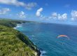
We began the hike at Bains Jaunes and headed toward Pas du Roy. This is the classic starting route for hiking La Soufrière. After about 10 minutes, you reach a fork where the path on the right leads to Galion waterfall. We continued at a steady pace toward the summit of La Soufrière and Savane à Mulets, which we reached about 20 minutes later. The weather was poor, and the sky was heavily overcast. I will not go into detail about this first section, since I already covered it in my article on La Soufrière. Maybe I was still tired from Barbados, but the pace felt slightly too fast for me, haha. This first section can really take it out of your legs.
Reaching Savane à Mulets confirmed my impression: the weather was really overcast and we couldn’t even see the summit of La Soufrière. We decided to head east toward Col de l’Échelle. The pass was almost completely shrouded in mist as we climbed. We reached it about 20 minutes later, still moving at a steady pace. We had started relatively late, and in these conditions there was no reason to linger. Today’s goal was to reach that plane. Col de l’Échelle was waterlogged; on all my previous crossings, I had never seen so many puddles. It was not an encouraging sign for the rest of the hike, especially near the wreck, where the ground is notoriously muddy. But we carry on. The trail around La Soufrière remained buried in cloud, and we were still walking through patches of fog.


We eventually reached the junction at Carmichael. A standard yellow trail sign marks the junction. The path on the left leads toward the summit of La Soufrière, while we continued along the Carmichael trail. So far, there was no particular difficulty; this was still the standard La Soufrière route via Col de l’Échelle.


Although we’re still on the official trail (GR G1), things began to get more demanding from here. The weather is still overcast and very threatening, but fortunately the rain held off. From this junction, the path climbs steadily, reaching an altitude of 1,400 metres after about 1.5 kilometres. The trail was still relatively easy to follow, but we continue to climb up and down the various hills in the area, with a few long, tiring steps along the way. I have to admit that I found the constant climbing and descending tiring. The atmosphere felt eerie, and visibility was close to zero. Even so, everyone was enjoying the experience and making the most of this unusual moment away from the crowds.


Despite the punishing sections, some stretches were genuinely unusual and enjoyable. The route passes through several areas of dense undergrowth with a remarkable atmosphere. The landscape is covered in a thick layer of moss. The photos may not quite capture it, but these sections were a real pleasure to walk through. The route remained manageable, even though my legs were beginning to ache.


As mentioned earlier, the trail remains fairly passable until the junction on the right shown on the topographic map. From there, we left the GR G1 and took a closed path marked with an orange cross. I will repeat the warning: from this point onward, you are responsible for your own decision, because you are no longer on an official trail—much like going off-piste at a ski resort. Up to this point, careful hikers may be able to keep their feet dry. Beyond it, that becomes almost impossible. A few meters after leaving the official trail, we understood why it was closed… This is where the real trouble began, although the final descent to the plane would be worse still.
From this junction, the descent is only about 350 meters. That does not sound like much, but the route no longer resembled a hiking trail. Plenty of people clearly pass through here, and we even met two hikers coming back up from the wreck. They gave us useful advice about the final junction on the descent to the wreck. More on that later. Rain had badly eroded the supposed path, carving channels into it and leaving puddles everywhere. The terrain was extremely slippery and dangerous. Every step required care, and from this point on it was almost impossible to keep our feet dry as we slid around.


One unusual feature of this section is that it passes through several miniature canyons carved by flowing water. We often had to duck beneath vegetation that was nearly as tall as we were. The ground is very slippery and full of water.


Despite how difficult the walking was, everyone was still having a great time, haha. We continued along the route shown on the topographic map and in the Maps.me app, which is worth downloading in advance. It uses your phone’s GPS to show your position on offline maps, provided you download them beforehand. But the hardest part was still ahead. The two hikers we met confirmed that we should stay on this route, then head downhill at the junction marked by the well-known “red cap.” It was clearly visible when we passed, though its condition may change over time.
The terrain became rougher and harder to cross, so I put my camera away rather than risk breaking it, haha. We began a seemingly endless descent through trees, roots, rocks, and mud. There was clearly no real trail here, although signs of repeated passage were visible. The descent demanded constant attention to avoid slipping, and weaving between the branches felt like an obstacle course. At the bottom, we reached the muddy area the two hikers had warned us about. We quickly realized that these were broad, swampy patches where water had collected. The scene was completely chaotic, and I stopped trying too hard to keep my feet dry because I was already soaked and covered in mud. With careful foot placement along the edges, you might limit the damage to muddy shoes. We slipped several times in this filthy terrain, and more than once I sank into the mud up to my knees. What a struggle, haha.


We were making so little progress that the section felt endless. Once past the mud, we finally spotted the first pieces of the aircraft below us, including a wing. We scrambled down through the roots as best we could until we reached the wreck. It lies in the middle of the forest and is remarkably intact for a wreck more than 50 years old, dating from September 9, 1971. We were all relieved to have finally arrived, but I have to admit that the place felt strange. This is the site of a crash in which both pilots died, so the story behind it is deeply somber. We stopped for a picnic. It took us about 2 hours and 30 minutes to reach the wreck from Bains Jaunes, moving at a fairly steady pace with a few breaks.
I spent some time photographing the aircraft from different angles and capturing details, which you can see below. It is a real shame that so many people have covered both the inside and outside of the aircraft with graffiti. It is upsetting to see, so anyone who goes there should respect the site and avoid damaging anything. It should go without saying, but take everything you bring back out with you.


The fuselage is fairly intact, but there are pieces of it all over the place, especially the propeller at the front of the aircraft. Vegetation is gradually reclaiming the site, growing around and through parts of the aircraft.


As we finished eating, another group of four arrived, so we decided to leave. We set off again along the same path. The return was just as difficult, although the climb seemed to go faster. The rain was still holding off, which was good news. Given the state of the trail and the humidity, it was clear that this area receives a great deal of rain.
We eventually made it back to the official GR G1 junction. We decided to return via Chemin des Dames, a route only I knew. I have to admit that the climb from the Carmichael junction to the foot of La Soufrière, near Grande Faille, exhausted me. The final sections and switchbacks were brutal, and I was close to cramping. We then slowed the pace on Chemin des Dames, which had been rebuilt after Storm Fiona damaged several sections of the trail. My companions did not know this route, which I believe is the longer way back to the old Savane à Mulets parking lot.


On the lower part of Chemin des Dames, the clouds briefly cleared, revealing a beautiful view of the Nez Cassé summit—another hike we hope to do one day, with what must be wide panoramic views. In the distance, we could see the towns of Saint-Claude and Basse-Terre.


We finished the mountain hike by descending Pas du Roy, the same trail we had taken on the way up. The descent made my legs hurt even more, and they felt heavier with every step. We finally returned at 4 p.m. We were delighted to be back before nightfall, which was not far off.
In the end, the GPS recorded almost 12 km over a total of seven hours, including a break of about an hour at lunchtime and a very leisurely return. Our actual walking time was probably around five hours, which felt substantial given the conditions.
Back at the car, we changed out of our muddy clothes. We happily soaked in the warm water at Bains Jaunes for 15 minutes. It felt wonderful.
My thoughts on the DC-3 wreck hike at La Soufrière
So, what did I take away from this hike? Although I have not completed every hike in Guadeloupe, this was by far the hardest and most tiring one I have done here. As mentioned earlier, this is not an official hike: the route is closed. I am therefore not encouraging anyone to attempt it, haha.
Personally, I am very glad I went, and I have even considered taking Mélanie next time—after warning her exactly what she would be getting into. Only you can decide whether this kind of outing is for you, but you need to expect a hard day: getting wet, covered in mud, and spending most of the day on foot. It demands a major physical and mental effort and is clearly not for everyone.
The story of the DC-3 wreck
I had not known the story behind the wreck, so I did some online research to learn more. Here’s a summary of what I found:
- On September 9, 1971, the Douglas R4D-6 (DC-3) of CARIB WEST AIRWAYS crashed into the slopes of La Soufrière. The wreckage was found four days later, on September 13, 1971; both pilots had died. They had been crushed by their 800 kg cargo of boat parts.
- The flight was traveling between Port of Spain, Trinidad, and Dominica. Because bad weather had delayed its departure, the aircraft was diverted to Raizet Airport in Pointe-à-Pitre, but it never reached its destination.
Practical information
I will not repeat everything you need to know about reaching Bains Jaunes. You can find those details in my article about La Soufrière. But here are a few tips:
Tips and what to bring for the DC-3 wreck hike
As mentioned above, we left at 9 a.m. and returned at 4 p.m. We stopped for an hour at lunch and took the return fairly slowly, although our overall walking pace was brisk. On the way back, we passed people who were still heading toward the wreck. I do not think they had accounted for how soon it would be dark. Set out early so that nightfall does not become an additional risk.
Another essential piece of advice—one repeated in nearly every article or video about this route—is to check the weather forecast and recent conditions. Do not attempt this route if it is raining around La Soufrière or if the area has received heavy rain in the preceding days. You will be soaked, and the terrain may become impassable.
For equipment, I recommend bringing the following:
- A waterproof daypack, if possible, for carrying food and water. I carried 2.5 liters of water for the day, which was enough for me, but individual needs vary.
- A rain jacket or poncho: essential if the weather deteriorates.
- Energy bars: useful for a quick boost when your energy drops.
- A waterproof dry bag: highly recommended for protecting camera gear or other equipment in heavy rain.
- A mobile phone: reception is limited on the trail, but your phone can still help with navigation, especially with offline maps in Maps.me.
- A hiking GPS: I use a Garmin eTrex 35, which I carry on all my hikes. It allows you to import the GPS track provided here. The aircraft coordinates are 643187.99 / 1775953.91 (or -> lat. 16.05926, long. -61.66138). For a closer look, the wreck is visible in satellite imagery on Google Earth or IGN Géoportail.
Here is the IGN topographic map of the area at 1:25,000 scale. My GPS track appears in blue, showing the outbound route via Col de l’Échelle and the return via Chemin des Dames. You can download the GPS track HERE
For other hikes in the area, here are a few ideas:
- The hike to the top of Nez Cassé, mentioned above, which I have not completed yet.
- The summit of L’Échelle, east of La Soufrière.
- Explore Parabole Falls above the Blue Basin
- The summit of La Citerne, a little farther south.
That brings us to the end of this article about the plane wreck. It is a memorable experience, if only because of the difficulty of the route. Again, it is clearly not for everyone, but those prepared for the challenge will find it a remarkable adventure.
See you soon for another hike in Guadeloupe!

Written by Sylvain PONS
Since 2021, I've been living in the Guadeloupe archipelago with Mélanie and our two children. We are exploring these beautiful islands and discovering the treasures that we are happy to share with you!
Despite our care, a mistake may have slipped into this article. If you find any, please don't hesitate to let us know so we can correct it as soon as possible and keep our information up-to-date!